THE indigo water of the Caribbean deep, bordered with azure and emerald on the edges of its white coral shores; limitless expanses of gray-green tree-tops stretching beyond far distant horizons, with lonely green mounds marking the ruins of palaces and temples built in Yucatan before the Normans ever came to England and in Guatemala when the Romans ruled the world. The great gorge of the Usumacinta River and the water-soaked wastes of Tabasco; the unknown lakes of Quintana Roo and Chiapas; the vast, flowering, tropical rain-forest of Guatemala; wide cloud shadows spotted over illimitable vistas; rain, wind, and heat; the sea and the sun and the sky. All these and many other beautiful settings formed the background of the Central American Expedition of the University Museum which set forth in December 1930 to explore the land of the Mayas from an airplane.
The expedition consisted of J. Alden Mason, Curator of the Museum’s American Section, as archaeologist; Gregory Mason, a writer1 and an archaeologist, of New York City, as field leader; Robert A. Smith,2 of the Fairchild Aerial Survey Company of New York, as photographer, and Percy C. Madeira, Jr., of Philadelphia, as director. It was financed in part by the Evening Bulletin of Philadelphia and the New York Times, and the grateful appreciation of the University Museum is here extended to these newspapers for their interest in and assistance to this project. It is also most cordially extended to the responsible officials of the Mexican and Guatemalan Governments for their courtesy in granting the necessary permits; to Colonel Charles A. Lindbergh and Dr. A. V. Kidder, of Carnegie Institution, for their suggestions and advice on the work based on their previous experience in a somewhat similar project in 1929; to Mr. J. M. Eaton and Mr. R. I. Dunten of the Pan American Airways Company and their assistants for their extraordinary helpfulness throughout; and to the many individuals hereafter named whom we met in the course of the expedition for their hospitality and kindness.
The object of the expedition was to investigate the ancient Maya civilization of Central America from both air and land, particularly in those areas not previously covered by either method. A brief summary of the achievements of this great early American people, a description of the territory within which they flourished, and an outline of the means of exploration employed, will be useful toward the proper understanding of the undertaking.
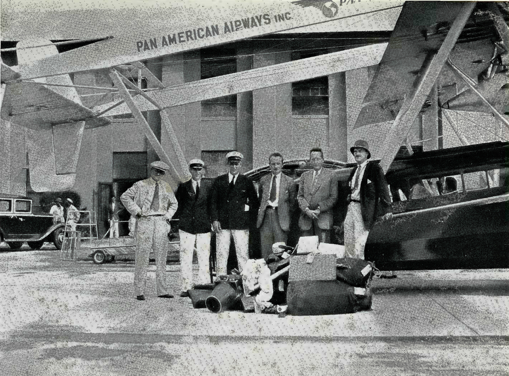
Image Number: 28425
The Maya people of Central America had developed the foremost civilization in the Western Hemisphere long before the arrival of Europeans, and fifteen hundred years ago were in some respects the most advanced race in the world. Their civilization is generally believed to have been the rapid development in a moist tropical region of the archaic culture which began nearly five thousand years ago, with the domestication of wild corn and other indigenous plants in the semi-arid highlands of Mexico, and which thenceforth spread all over America.
Who the Mayas were, what name they called themselves, and whence they came are subjects of discussion outside the scope of this report, but it is now generally conceded that they were of purely American Indian stock. Shortly before the beginning of the Christian era, these peoples had settled in large numbers in Guatemala, in the adjoining states of Tabasco and Chiapas in southern Mexico, and in northern Honduras and the southern part of British Honduras. They then commenced the construction in numerous places throughout this area of the great complexes of stone buildings which formed the administrative and ceremonial centers of the population surrounding them. These usually consisted of long, low structures, commonly called palaces, which are believed to have been the homes of the rulers and priests, and of high artificial elevations supporting small buildings, generally called temples, which were almost certainly places of worship, and might be termed gigantic altars.
If a circle with a radius of one hundred miles be drawn, with Lake Flores in northern Guatemala as its center, it will include, with possibly one or two notable exceptions, every large site where Maya ruins of the earlier type have been found, and will embrace all of the great cities of what may be called the First Empire of the Mayas.
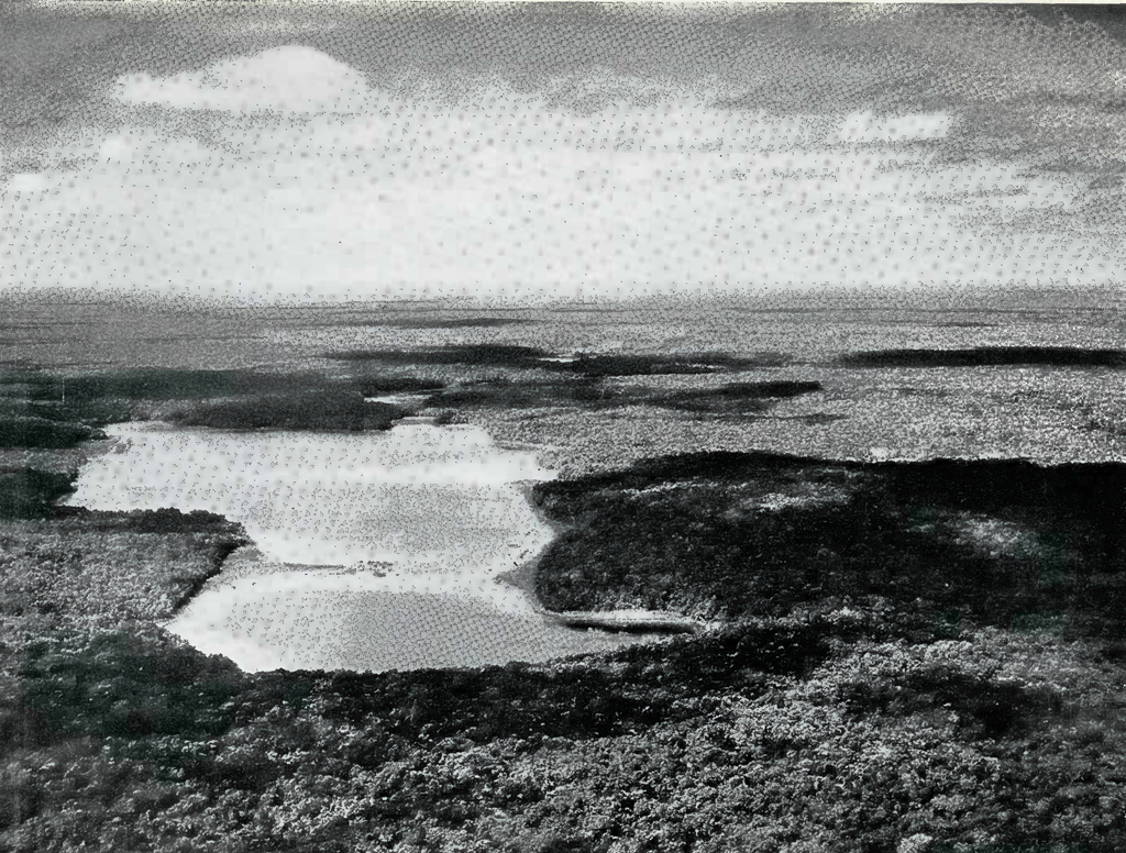
Image Number: 18910
In view of the discoveries made in eastern Quintana Roo during the past few years, of monuments dated as early as many found in the Guatemalan cities, it seems desirable to abandon the former terminology of Old and New Empires, hitherto used by many archaeologists for the two phases of Maya culture, in favor of names such as First and Second Empires which do not so sharply separate in terms of time the principal areas of the two phases of this civilization.
The First Empire, with its center in Guatemala and a few outposts on and inland from the east coast of the peninsula of Yucatan, lasted for more than six hundred years after the beginning of the Christian era, during which centuries the Angles and Saxons were skin-clad barbarians in the North German forests. Different cities were built by the Mayas during this time in many different places in the area already described, and then this great civilization, due to a variety of causes not clearly understood, suddenly began to disappear. One by one, at widely different dates and in widely
different places, the great stone palaces and temples in this southern region were abandoned to be swallowed up by the tropical jungle until about A. D. 629,3 as far as is now known, the First Empire in the southern region was at an end.
During its great period in this southern area, the Maya people exe-cuted works in sculpture,4 painting and pottery beyond the skill of the Egyptians or of any other early civilized people, their art showing a knowledge of the laws of foreshortening and perspective which the Egyptians or Assyrians never knew. Their architecture,5 especially at Palenque, compared very favorably with that of any peoples contemporaneous with them, with one or two notable exceptions. Their hieroglyphic writing, developed long before the Christian era, was very elaborate and is totally different from that of any other people.
It was, however, in mathematics and astronomy that the ancient Mayas reached their greatest heights. In these two fields of knowledge they far surpassed any people who had ever existed before them, not excepting the Hindus, Greeks, Romans or early Europeans. The Maya were the first of all peoples to invent the idea of zero and of place value in numbers (that is, the theory of a decimal system), thus permitting them to multiply and divide at least six hundred years before this same idea was again discovered independently by the Hindus and from them, through the Arabs, carried to Europe. This abstract mathematical conception consequently reached the white races from an alien source nearly one thousand years after the great astronomer-priests of the Mayas had used it on hundreds of occasions to record on their stone buildings and monuments dates in a calendar running back to 613 B. c. This calendar must have been based on centuries of stellar observations, and was far more accurate than that used by Europeans when Columbus first saw the green islands of the Caribbean Sea. The calendar of the Maya people is unlike any other ever devised, and its extraordinary accuracy entitles it to be classed as one of the greatest developments in abstract thought ever made by any people.
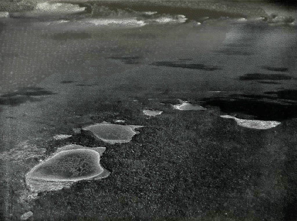
Image Number: 18926
Centuries after the last known date so far found on the monuments in the southern area or in the eastern part of the peninsula of Yucatan, the same civilization of the same people, with a far finer architecture and wonderful woven fabrics and feather work, but inferior in sculpture and pottery, appeared once more in northern Yucatan and culminated in the great centers of Chichen Itza and Uxmal. This Second Empire, which was nearing its height at the time of the Norman Conquest of England, continued, with some modifications in its art and religion from Mexico about 1200, until its great city of Mayapan was destroyed in a civil war about 1451. After this, owing to further civil wars, and to hurricanes and disease, the Second Empire of the Maya rapidly declined and was far past its peak when the Spaniards first landed in force in Yucatan in 1519. The descendants of these people, speaking the same language and with many of the same customs, live in this country today.
In A. D. 500 and again in A. D. 1300, it is quite probable that the Maya civilization compared favorably both in art and in science with any then existing in the world. Certainly at both of these periods it was, with the exception of the general use of metals which do not exist in this area, and perhaps in its social and religious concepts, equal to any contemporaneous western European civilization. The centers of the First and Second Empires at their peaks were in all likelihood among the most densely populated regions of the world. It is interesting to note that all of the work of these people in building their great structures was done with stone tools and by human labor, as there were no horses or cattle in the Western Hemisphere before the coming of the white man.6
A brief statement about the country itself will be helpful to show the size and characteristics of the region covered by the expedition. The word ” Yucatan ” as used in this article, unless otherwise specified, means the peninsula of Yucatan, and not the local province within it. This peninsula, which is nearly due west of Cuba, contains the Mexican states of Yucatan, Campeche and Quintana Roo, as well as the crown colony of British Honduras, and covers an area slightly larger than that of the state of Pennsylvania. It is about two hundred and fifty miles long north and south and two hundred miles wide east and west, and thus includes fifty thousand square miles. Yucatan is cut off from Mexico by hundreds of miles of jungle and swamp through which no rail, nor road, nor wire runs, the only communication being by sea or air. The state of Yucatan is fairly well settled, but most of Campeche and nearly all of Quintana Roo is still covered with the growth of centuries and inhabited by small groups of natives in villages far apart and linked together only by mule trails. South of Yucatan the Mexican states of Chiapas and Tabasco, and the republics of Guatemala and Honduras comprise the balance of the country of the Mayas.
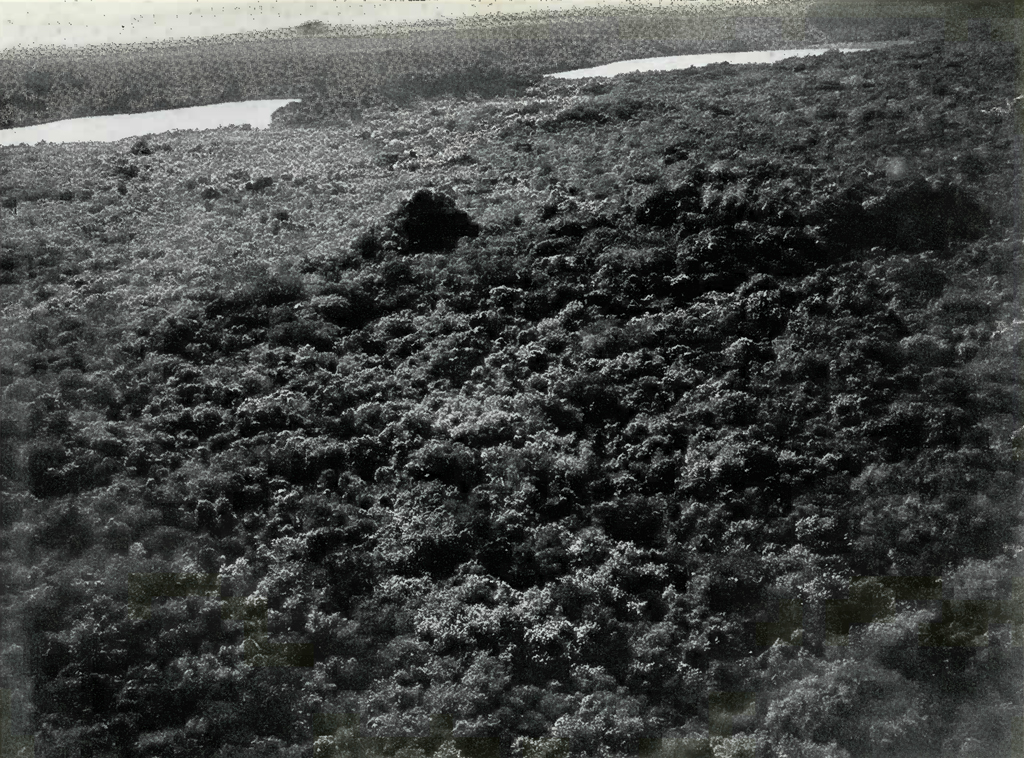
Image Number: 18932
Geologically, much of Yucatan is of quaternary limestone formation, so recent in origin that it is still mostly porous. Consequently, the rains seep rapidly through the surface and thus leave the area without a single important river except in the extreme southwestern part of the state of Campeche. The peninsula is nearly flat except for a band of rolling, broken country, running nearly north and south in the western portion of the peninsula throughout its entire length, with two ranges of higher hills which are off-shoots from this region. These start near Uxmal and extend at angles toward the southeast and southwest, the latter range dwindling out into the great central plain after a comparatively few miles. A chain of hills runs north-northeast and south-southwest along the east coast near the sea, commencing in western British Honduras. This formation becomes a low flat plateau west of Lake Bacalar studded with hills and broken by patches of lower soggy country, and gradually dies out around Tuluum. In the extreme southern parts of Quintana Roo and Campeche the country becomes more rugged. Low hills are found in northern and central Guatemala, and higher hills or low mountains along the upper reaches of the Usumacinta River and in southwestern British Honduras, where several of the most celebrated First Empire cities have been discovered.
The climate of this region is dry from December to May, with a heavy rainy season in mid-summer and again in October and November. In the winter the temperature near the sea is about the same as that of Miami, Florida; that is, between 70° and 80° at all times in the shade, but much hotter in the sun. Inland and in the rainy area to the south it is on an average perhaps 10° warmer and much more disagreeable because of the high humidity.
The airplane used by the expedition was a Sikorsky amphibian biplane, model S 38, No. NC 8044, having space for four passengers. It was equipped with two 425-horse-power Pratt and Whitney Wasp engines, and flew at a normal cruising speed of eighty-five nautical miles, or about one hundred land miles an hour. This great machine was chartered by special arrangement with the Pan-American Airways Company, starting from Miami, Florida. Owing to the amount of weight carried, and the wild nature of the country to be covered, as a measure of safety the surplus gasoline tank was removed before leaving so as to permit the plane to remain in the air at a low altitude with only one motor working. This reduced the gasoline capacity to two hundred and twenty gallons. In operation the Sikorsky consumed on an average about fifty gallons an hour so that the distance it was possible to fly without refueling was limited to a little over four hours, or about four hundred land miles. The plane was equipped with a radio, with which it both sent and received messages. Under the company’s regulations, the position of the plane was reported by radio at regular intervals, and from time to time it received reports from its next destination about the local weather conditions. In actual flying the four members of the party sat in two rows of two seats one behind the other. The roar of the engines was so great that our ears were filled with cotton and all communication was by writing only. This was a serious defect in work of the kind undertaken by the expedition, as at times rapid changes of direction were desired which were difficult to communicate quickly to the pilot. Future expeditions of this general character should carry head phones with which the responsible leader can readily discuss with the pilot any desired deviation from the course.
The Pan-American Airways Company, who put all of their unusual facilities at our service and to whose help throughout much of the success of the expedition is due, have their principal base at Miami, but maintain landing places with fueling stations at Havana, and at San Julien near the western end of Cuba; at Cozumel Island, off the northeast coast of Yucatan; and at Belize, in British Honduras. Through a subsidiary Mexican company, they also have airports at Merida, the capital of the state of Yucatan, and at Carmen, a small island seaport off the southwest coast of the state of Campeche. None of these airports are more than three hours flying or three hundred miles apart; all are equipped with powerful radio apparatus, and all employ excellent mechanicians, who kept the plane in perfect condition.
Image Number: 18935
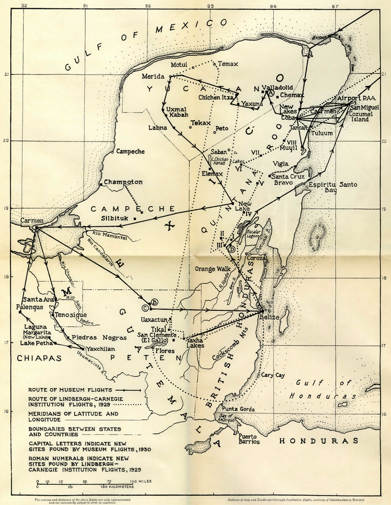
The expedition used the Blom-Ricketson-Spinden maps of the Maya area, 1929 edition, as their principal guide. In, addition, the U. S. Navy charts of the coastal area, and the 1930 official Mexican government maps of the region involved were carried and frequently consulted. The excellent and interesting report7 of the Lindbergh-Carnegie Institute flight of 1929 over other parts of the same area was also of the greatest value throughout. The routes covered by the two flights are shown in the map found at the beginning of this article, Plate 1.
The expedition carried with them almost all the equipment needed for work on land, as it was impossible to determine in advance what would be required. It was hoped that new sites near some lake or other landing place would be discovered where the plane could put us down to do field work. Part of the standard equipment of the plane consisted of a rubber boat and oars; and a shot gun and ammunition, blankets, ponchos, hammocks, machetes, canteens, a water bag and five days emergency rations were always in the plane as insurance against the outcome of a forced landing. As a matter of interest a full list of equipment carried is set forth in Appendix A hereto.
The party left the North on the Havana Special on the night of Sunday, November 30th, and arrived at its real starting point at Miami, on the morning of December 2d. After a certain amount of difficulty about the weight of our baggage, which compelled us to leave behind all but the most absolutely essential articles, the plane finally took off from the Miami airport at about 2 P. M. in charge of Captain Frank Ormsbee, who handled the ship superbly throughout, with William Carey, who splendidly supported him, as co-pilot and radio operator, as well as recorder of the compass bearings, courses, times, and other data on the flights. [Plate 2.] Favored with a strong following wind, the Sikorsky landed at Havana at a few minutes before four o’clock, covering the two hundred and sixty-one land miles of distance between the two cities in one hour and fifty-three minutes, or at the rate of about one hundred and thirty-five miles an hour. Leaving Havana the next morning, December 3d, at 7.42 A. M., we refueled at San Julien, Cuba, crossed the western end of the island at ten o’clock and reached the northeast coast of Yucatan at Cape Catoche at 11.08 A. M.
All maps and charts of this region showed a very large lagoon or indentation in the land a short distance west of Cape Catoche. This no longer exists. A flight over this area to examine it for possible ruins revealed that the lagoon was filled up except for a few shallow water courses. The plane then flew almost straight south about thirty miles inland from the sea over country which had not before been examined from the air. The extreme northeast portion of the peninsula is flat and overgrown with jungle, with a few scattered clearings here and there. For the most part, at least at the end of the rainy season, this area is so swampy that it is doubtful if it could have been inhabited in the past by large enough masses of people to have constructed any important sites.
At 11.57 the expedition arrived at the point where the lakes of Coba were shown on existing maps and found several bodies of water, but, as seen from the air, they did not fit the description of the site of that important city. There were no signs of any ruins. These lakes, which are located at approximately 87 degrees 42 minutes west longitude and 20 degrees 38 minutes north latitude, consist of one large body of water, more than a mile long and in places one half mile wide, with a pronounced shallow place in the middle, and four other lakes around it, three of them in a chain running due east and west. [Plate 3.] They are approximately 28 miles inland almost due west of the northern end of Cozumel Island. It was decided to name these lakes for the director of the expedition, and after they were photographed the Sikorsky headed for Cozumel Island. Three or more other lakes were in sight well to the south. The plane finally crossed over an Indian village on the edge of the sea, probably Playa Carmen, at 12.21 and landed on the beautiful blue lagoon of the Pan-American Airways Company’s Cozumel Island base at about 12.30. The morning trip covered one hour and twenty-five minutes flying time in Yucatan.
Cozumel Island, “The House of the Swallows” in the Maya language, was once a sacred spot to which the Mayas of old made pilgrimages from the mainland. It contains traces of several ancient stone roads and many small ruins and shrines lost and forgotten in the forest. The earliest historical mention of this little island is in the Chronicle of Chicxulub written in modern characters by the Maya, Nokuh Pech about 1562. This Chronicle includes the somewhat startling recital: “Thus the land was discovered by Aguilar who was eaten by Ah Naum Ah Pat at Cuzamil in the year 1517.”8
The party was met by the local manager of the Airways Company and about eight Mexican officials from the town of San Miguel Cozumel some ten miles away, headed by General Trevino, Governor of the island, and by the Chief of Customs, both friends of Mr. Gregory Mason as the result of his previous visits to the island. All immigration, customs and quarantine regulations were waived in our favor and these officials explained that they had come over early in the government launch in order to take the expedition to the town, where there was to be a fiesta, or party, which would start upon our arrival. We regretted that unfortunately there was so much to do and so little time in which to do it that it was not possible to accept their kind invitation just then, but said that we would be honored to be their guests in the evening. Four of the officials accepted at once an invitation to go up in the plane and took a short ride of some eight or ten minutes. They then left after promising to send the customs boat back about five o’clock the same afternoon.
Image Number: 18957
At 2.05 P.M. the plane again left the airport and flew straight south along the long axis of Cozumel Island, which was absolutely flat and covered with thick jungle except for a few scattered clearings close to the sea. Photographs of the island were taken from the air, and at 2.25 the plane headed due west for the mainland to return to the lakes first seen in the morning. From an altitude of about 6700 feet, three large lakes, and one small one, were plainly visible, well to the south. Ten minutes later the shore line was crossed and at 2.50 the plane was over what were at first thought to be the lakes examined in the morning, but which on closer inspection were found to be a different group. The flight was continued northward and in a few minutes the lakes previously visited were reached and again examined carefully for ruins, the plane flying almost over the treetops, but as no evidence of buildings were seen, we returned to the other group of four lakes, still flying low. This second group proved to be the lakes of Coba, and were found to run roughly in a line west-northwest and east-southeast, the two larger ones being toward the northwest. [Plate 4.] Near the north bank of the second large lake a pyramid and large mound showed plainly through the trees with evidences of masonry visible in several places. These ruins were seen several miles away and thus taught us the technique of ruin hunting. Mounds marking the site of ruins are nearly invisible from an altitude of more than 1000 feet but show up on the skyline when the plane is low down over the flat country characteristic of this region. The vegetation on them also seems different in some indescribable way from that of the surrounding country.
The principal structures seen at Coba were a very large mound and a pyramid at the edge of the largest lake to the west, the two ruins just north of the second lake, and an enormous mound, which probably contains more than one building, rising on the neck of land between the two bodies of water. The site is one of the oldest in Yucatan, and was settled long before Chichen Itza. During the period of the First Empire fifteen centuries ago it was probably the largest and most important city in the Yucatan peninsula. These ruins of Coba were photographed from the air at a low altitude; Mr. Smith, then as always, working from what seemed to the rest of the party an appallingly dangerous position. [Plates 5 and 6.] The plane then rose to a considerable height and thus revealed a causeway starting between the two large lakes and running south, another running south from the second large lake and intersecting with the first causeway, and a third causeway running due north. These ancient stone roads, built more than a thousand years ago, now show up from the air as straight lines of vegetation, which like that on the ruins differs in some indefinable way from the surrounding forest. Photographs of these causeways were taken in which they appear very plainly, more so, in fact, than they did to the eye at the time. No causeway was visible running west to the site of Yaxuna, south of Chichen Itza some seventy miles away, although it had been reported by several previous visitors to Coba, and partly cleared by R. R. Bennett,9 whose accounts of his work there are most interesting.
At a few minutes after four, the plane left the site of Coba and reached the coast at 4.18. From the bearings taken on these two flights to Coba and the time from the site to the coast, as well as the plotting of the next morning’s trip, the position of the Coba Lakes and ruins appears to be at approximately 87 degrees 42 minutes west longitude and 20 degrees 30 minutes north latitude. This location is about ten miles south of the position shown on the large maps of the expedition and, allowing for wind drift, about twenty-five miles inland from the sea in a line running due west from a point about nine miles north of the southern end of Cozumel Island. This finding checks very closely with the position of Coba as determined by the Lindbergh-Carnegie Institution flight of 1929,10 except that, according to the Museum Expedition’s calculations, it is about four miles farther inland and perhaps five miles more to the north.
Once more the plane flew lengthwise over Cozumel Island, passing above an artificial mound near its north end which was examined carefully from a low altitude but showed no signs of masonry. It is probable that this is a ruin of some kind which has apparently not been reported. This northern part of the island is very low and swampy and seems to be almost uninhabitable in the rainy season. The expedition landed at the Cozumel Island Lagoon at ten minutes of five, after two hours and forty-five minutes flying time for the afternoon, or four hours and ten minutes for the day over Yucatan.
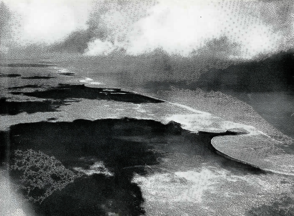
Image Number: 18916
In talking over the work, the pilot advised that a plane as large as the Sikorsky could easily land on and take off from the largest lake of the first group seen north of the Coba Lakes, except for the shallow place in the middle about whose depth he was uncertain. On the other hand, such a large plane should not land on the water at Coba unless forced to do so. According to Captain Ormsbee the chances of a successful take-off would be greatly in favor of the plane, but the high trees on the neck of land between the two larger Coba lakes rendered it a little uncertain, and the risk would not ordinarily be justified. In the Carnegie Institution flight over these lakes with the same type of plane, Colonel Lindbergh reached the same conclusion. The larger lakes at Coba could, however, be easily used today as a landing place for an autogiro or a light 300-horse-power plane equipped with pontoons; or even for a plane the size of a Sikorsky amphibian, if the trees on the neck of land between the two large lakes were cut down. This would not be a very difficult or lengthy undertaking for a ground party.
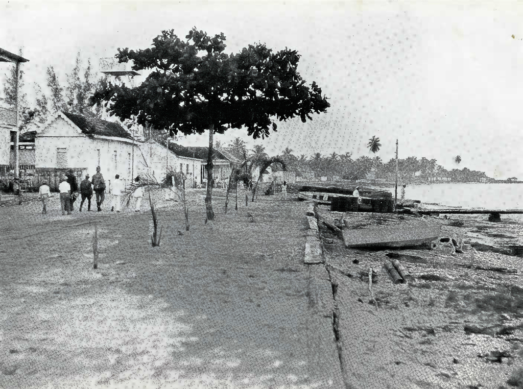
After changing clothes, we took the government launch on a rough and wet ride to the little town of San Miguel Cozumel, some ten miles away. The island of Cozumel is now inhabited by about 1500 people, nearly all of whom are pure Maya Indians. They are short in stature, averaging perhaps 5 feet 4 inches in height, but very strong. Their skin is not red, but a light bronze, and they are exceedingly clean. The port of San Miguel Cozumel [Plate 7] owes its existence to the chicle industry of Yucatan. This product, which is the hardened juice of the sapote tree and forms the base of all chewing gum, is exported from eastern Yucatan entirely through this one little place.
We were met at the dock by General Trevino and other officials, who furnished us with most hospitable entertainment including the famous Mexican drink “tequila” — of which a little goes a long way — and a most lavish dinner, followed by a display of rockets and then a dance, attended by all the unmarried women of the village and all the men and boys of every size and age. The women of these people marry at about fifteen and thereafter are not permitted to take part in public entertainments, so that the eligible partners at the dance were rather youthful. Our party were introduced to various members of the fair sex in their early teens, but being unfamiliar with the music and their style of dancing, could not compete with the local talent. Two flashlights of the dance hall were taken while the ball was in progress, but unfortunately they did not develop very well. The night was spent in the town in quarters generously furnished us by General Trevino, as there are no sleeping accommodations at the airport of the Pan-American Airways Company. A five-inch scorpion picked Dr. Mason as a sleeping partner sometime during the early hours, but apparently appreciated the latter’s hospitality as it did not attack him.
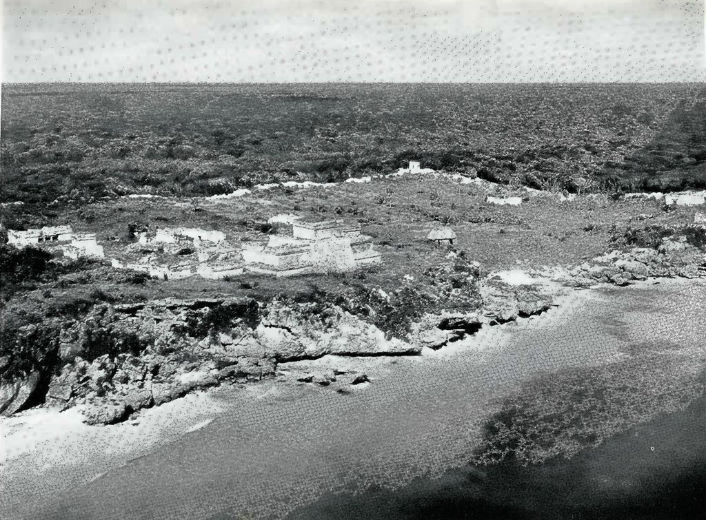
Image Number: 18969
We returned to the airport the next morning, December 4th, in the customs’ launch and left the lagoon at 10.55 A. M. We first tried flying over the sea with only one engine. The right motor was cut off at about 1200 feet altitude with the plane carrying a full load of 3200 pounds. During the next ten miles the plane settled down to an altitude of about 250 feet, and then held this level indefinitely. At 11.05 the mainland was reached directly over the Indian village of Playa Carmen, which contains six to eight thatched huts near some ruins a few hundred yards away, known by the same name. From this point we flew south, very low and along the edge of the ocean to examine the coast carefully for ruins other than those now on existing maps. This part of the east coast of Yucatan contains a succession of small ruins first located by the Mason-Spinden Expedition of 1926. Paal-mul, one of the largest, with an Indian village of the same name, is shown on Plate 8. The sites, as described by Gregory Mason in his very interesting popular book on that trip, run along the coast “like the towns along the Connecticut shore.”11 The shore line was scalloped, and a low ridge ran parallel to the sea about three quarters of a mile back from the beach. [Plate 9.]
For more than half an hour the flight led south, past forgotten temples and desolate altars, lonely relics of a lost religion, until at 11.45 the expedition reached the well-known city of Tuluum.12 These ruins, perched on the edge of precipitous cliffs, showed up magnificently from the air across the brilliant blue of the sea sparkling in the flaming light of the noon-day sun. [Plate 10.] As this site has been cleared and thoroughly examined on several occasions, no landing was made but several photographs were taken of the ruins and the course was then continued to the south. The ridge a little way inland, running parallel to the sea, disappeared at Tuluum. The country west from the coast while nearly flat, was in general higher above sea level than before, and a very definite low plateau ran north for some distance in the direction of Coba. Like the rest of the country in Quintana Roo, all this area is densely covered with trees, scrub and vegetation.
At 12.15 the plane reached Muyil, a large site, also discovered by the Mason-Spinden Expedition of 1926. Its high tower showed up very plainly through the vegetation, but none of the other numerous ruins of this rather important city were visible. From Muyil, a southern course was taken along the shores of two near-by lakes connected by an ancient Maya canal, but no signs whatever of ruins were found, and five minutes later the plane headed north for Coba on a course about twenty-five miles inland. As the map shows, this region between Muyil and Coba was not covered by the Lindbergh-Carnegie Institution flight of 1929.
The visibility on this course was poor; great masses of cumulus clouds cast heavy shadows on the jungle and made it difficult to distinguish elevations except when flying just above the treetops. This is too hard on the nerves to continue for more than a limited space of time and the average altitude of the plane was about 1000 feet with occasional dips to the lower level. No ruins were seen between the lakes near Muyil and Coba, although it is almost certain that some exist in the dense scrub of this region.
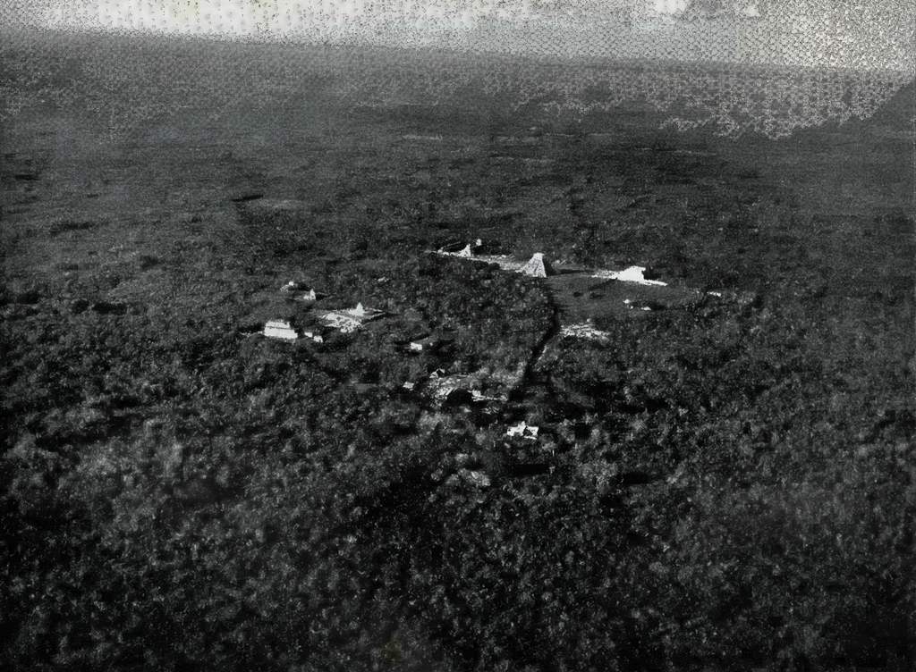
Image Number: 19006
Just south of Coba several dried up lakes and small “cenotes ” or natural water holes, covered with scum, were plainly visible from the air. A large crescent-shaped lake was seen at the southern edge of the site of Coba. This lake had completely dried up in very recent times and is probably one of those reported previously as part of the Coba Lakes group. Coba itself was reached at 12.45 and again the expedition tried without success to see the causeway running west. The other causeways seen on the previous day showed up plainly. We flew down very low over the northwest and largest lake, almost touching the water, but Captain Ormsbee again declined to land for reasons already given. In order to measure the size of the two largest lakes by airplane speed, we flew lengthwise over both of them in each direction. On an average of the two courses the northwest and largest one was covered in seventeen seconds, the second one in fifteen seconds. Assuming an airplane speed of one hundred land miles an hour, which is almost the equivalent of eighty-five nautical miles, the northwestern and largest lake is about 2500 feet long and the other lake 2100 feet. A new hut, used by several recent land expeditions and probably built by one of the Indian chicle gatherers of the province, was seen on the north shore of the largest lake. The natives living there waved at the plane as it circled above them.
At 1.16 the plane left Coba for Cozumel, flying on a 90 degrees course due east to find where it would intersect with the island. At 1.36 the coast was reached, a total of twenty minutes from Coba to the sea in a direct line to Cozumel Island or a distance of about twenty-five nautical miles, after allowing for a head wind estimated to be at least ten miles an hour. At 1.46, still flying on the same course due east from Coba, the western coast of Cozumel Island was reached about nine miles north of the southern tip. This confirmed our previous calculations. At 1.54 the plane landed again at the Cozumel Island Lagoon airport, after three hours of flying for the morning’s work.
In the afternoon the expedition left the lagoon at 3.15 and again headed for Coba at an altitude of about 2000 feet on a bearing of 260 degrees. At 3.31 we crossed directly over a very broad trail running northwest and southeast in a straight line as far as it could be seen. This road or trail is about twelve miles inland and does not go toward Coba. It is undoubtedly a modern native trail, probably running from Tancah on the coast to Chemax, near Valladolid. At 3.49 Coba was reached, which again checked closely with previous bearings on its position, allowing for difference in altitude, starting position and wind drift. At 3.51 we left after locating faint traces of what was believed to be the east and west causeway running nearly seventy miles west to Yaxuna, a town south of Chichen Itza. A considerable part of this causeway has been covered on foot, and we hoped to fly over its entire length, as it seemed a most likely area in which to find new ruins. For a few minutes we succeeded in flying along the line where this thirty-foot-wide causeway lay on the ground. Thereafter traces of it showed up faintly now and then, but finally disappeared altogether.
At 3.55 a clearing was seen with six or eight Indian huts, Chemax being off to the north with its church tower showing very plainly. No ruins at that time could be seen straight ahead in the direction of the causeway, which was still invisible, but some suspicious looking mounds appeared a little to the northeast of Valladolid, so the course was altered and the mounds reached about four o’clock. [Ruin A, map.] While no masonry was observed, the arrangement of these mounds and their curiously artificial shapes suggests that they may be new ruins, as none are shown here on any map. This site is so near to Valladolid, however, that if the mounds are artificial it is curious they have not been reported before. Leaving these mounds, the plane flew southwest until 4.11 when it headed west toward Yaxuna. From then on our course was parallel to the line of the reported causeway as it showed on our maps, but we could not pick it up. A large tract of the country below was very swampy and covered with unusually dense forest. There were also a number of slight irregularities in this area, some of which were examined but found to be either clumps of trees or simply natural elevations.
At 4.28 the plane was over an Indian village, which Mr. Smith photographed. The course was still on a line for Yaxuna, which had not been found at its map location. At this village an old Spanish building near some Indian huts was plainly visible from the air. If this is Yaxuna, as is believed to be the case, it is at least eight miles west of its charted positions on the maps, and the old causeway from Coba is correspondingly longer than previously supposed.
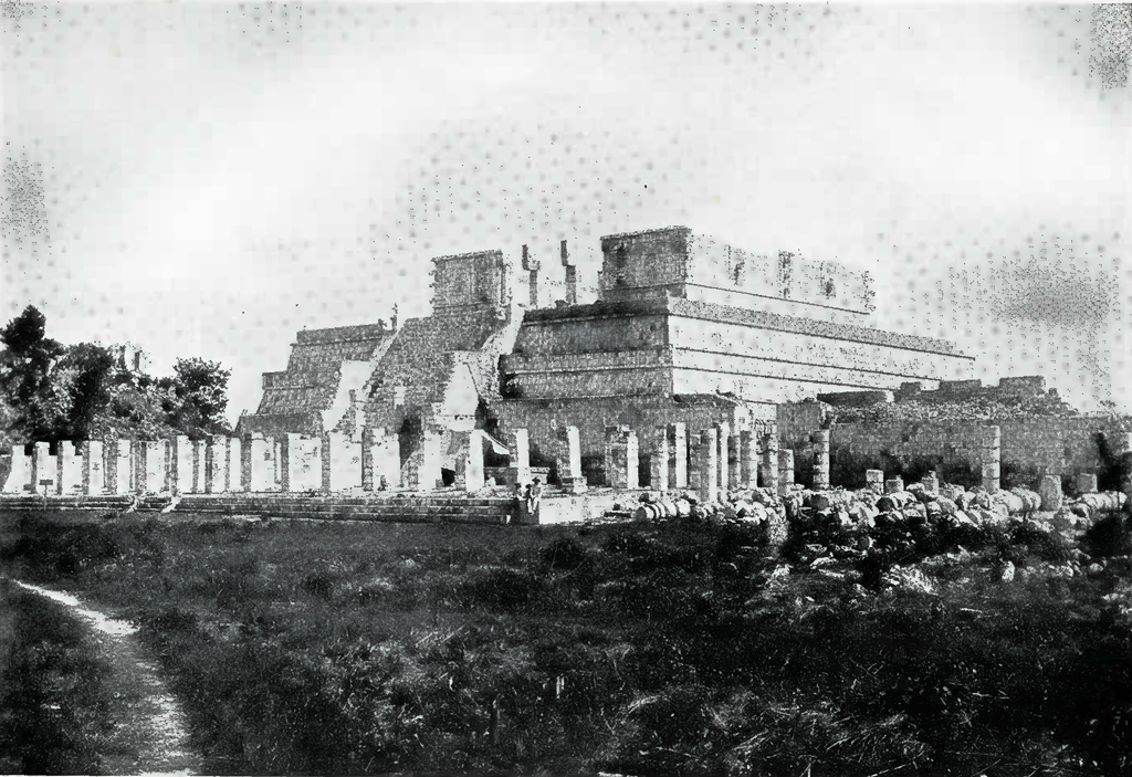
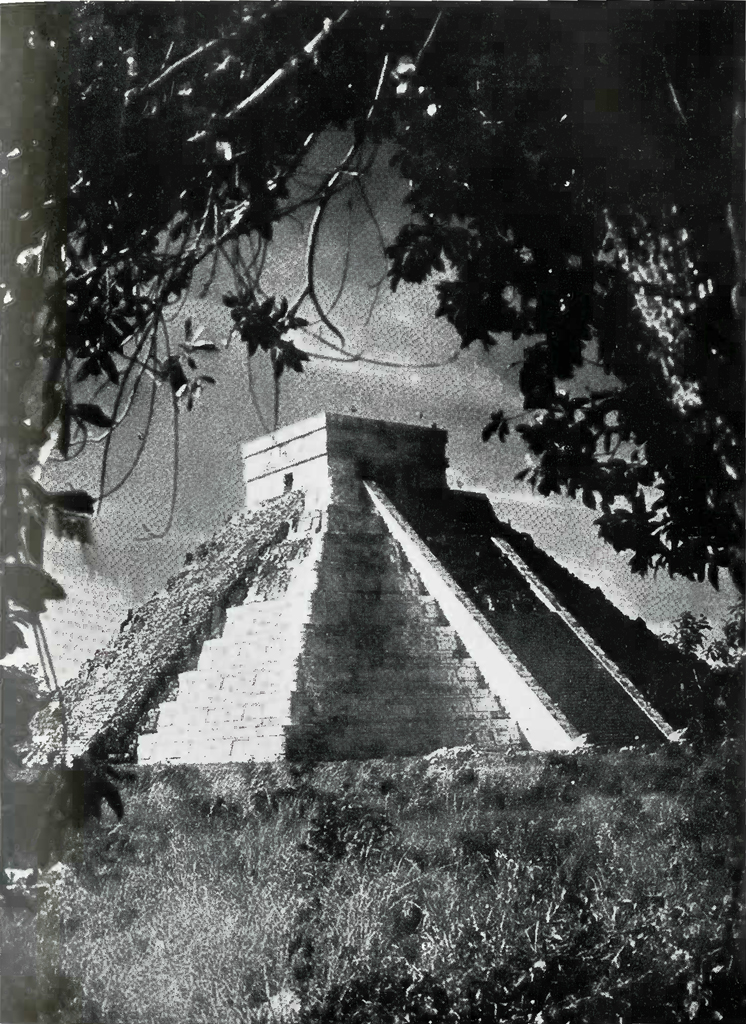
At 4.40 the superb city of (Chichen Itza was reached, where Mr. Smith took several air photographs. [Plate 11.1 These famous ruins showed up beautifully, especially the Temple of the Warriors and the Castillo, and are an enduring monument to the splendid work of Carnegie Institution and Dr. S. G. Morley and Mr. Earl Morris in excavating and restoring its temples and palaces for the benefit of posterity.13 We did not fly low enough to get close-up pictures, but as a matter of interest to those desiring to see details of the wonderful work of the Mayas, photographs of the Castillo, which is 110 feet high, and of the Temple of the Warriors, taken at another time from the ground, are shown in Plates 12 and 13.
At a quarter of five we left Chichen Itza for Merida. At five o’clock the remains of the very high stepped pyramid of Izamal, the highest ancient structure known in Yucatan, were plainly visible away to the north. At 5.28 the plane finally landed at Merida, the capital of the state of Yucatan. Here the expedition was met by a large assemblage of government officials, newspaper representatives and photographers, and Senor Fernando Barba-chano, the owner of the Mayaland Tours Agency and a friend of the writer’s as a result of a previous visit to this city. The afternoon’s flight lasted two hours and a quarter, or a total of five hours and a quarter in the air for the day.
After being photographed at the landing field, the expedition went to the excellent Gran Hotel and were interviewed by the press who gave us a most favorable write-up. We were later entertained at dinner by the writer’s friend, Senor Barbachano, in his home and afforded a very good illustration of the pleasant life of the Yucatecans at Merida, their courtesy and hospitality, and the excellence of their local foods.
Merida, a beautiful clean city of 80,000 people, with its houses colored pink or white or light blue, is the principal city of the peninsula of Yucatan. Its inhabitants are nearly all Maya Indians of almost pure stock, immaculately clothed in picturesque white suits which are kept spotlessly clean. There is also an upper stratum of Mexican officials and administrators, and an aristocracy of Spanish descent. Merida was founded in 1542 on the site of the ancient Maya city of Ti-Ho, and its principal residential building has been occupied continuously since 1548 by the lineal descendants of Francisco Montejo, the conqueror of Yucatan. It was a well-known and important city in the Western Hemisphere seventy-five years before the Mayflower ever reached Plymouth Rock.
From Merida as a center, a government-owned railway runs some twenty-five miles north to Progreso, the principal seaport of Yucatan. The Ward Line boats from New York touch here on their way to Vera Cruz and the Munson Line from New Orleans maintains a weekly service in the winter season. Other railroad lines run from Merida east to Valladolid, south to Tekax and Peto and southwest to Campeche, a seaport and the second largest city in Yucatan.
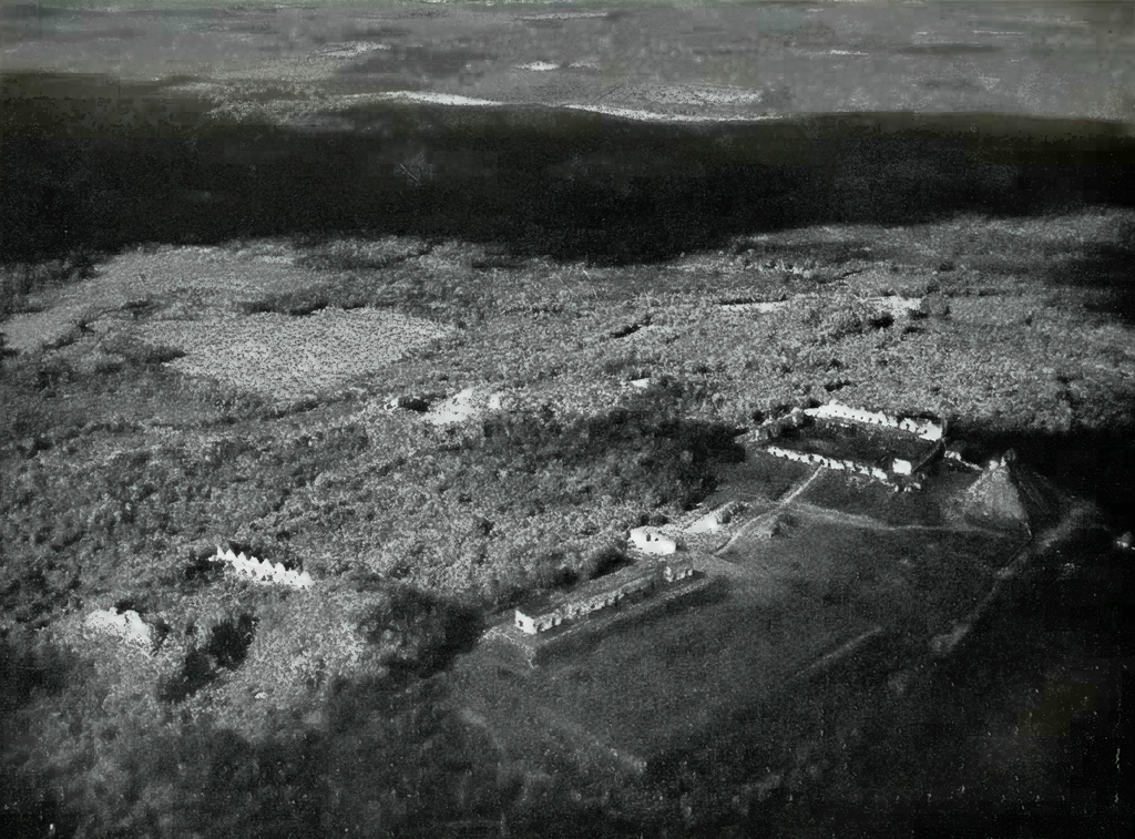
Image Number: 19009
At Merida is collected the henequen fibre which constitutes the principal and most important product of the state of Yucatan. This is made from the leaves of the agave cactus and is exported through Progreso in great quantities under the name of “sisal.” It is used principally to make binder twine for harvesting machines and other purposes, and, until very recently, northwest Yucatan was the only source of this material.
The city possesses at least two comfortable hotels with good food and running water in many of the rooms. It is about 100 miles by land from the ruins of Chichen Itza where a small modern hotel has recently been erected, and perhaps half that distance from the equally impressive ruins of Uxmal. It has a large and beautiful public square in the centre, its streets are as clean as those of Paris, and the principal approach by road from Progreso is a long beautiful avenue comparable to the Champs Elysees. Merida contains a wonderful museum with many superb examples of the work of the ancient Maya and the city is well worth a visit during the winter season. It is also the center from which to start for all the best known and best preserved ruins of the Maya civilization in Yucatan.
The next morning, December 5th, some of our party called upon Dr. Martinez, of Merida, one of the leading authorities on the Maya civilization.14 Later we gathered in the house of a friend of Senor Barbachano and were introduced to a forester of the Mexican Government, with whom we discussed the prospects of finding some hitherto unexplored ruins in the adjacent region near any body of water large enough for our plane to land on with safety. According to the forester, the only hitherto unexplored site of any size within available distance from Merida was a two days’ journey by mule from a lake on which the plane would have to land. This body of water in turn was far from any settlement, requiring that arrangements be made ahead for us to be met by men and animals who would have to come from another settlement some twenty miles away. The forester said he could attend to all these details, but the whole project, especially the size of the ruins and the location of the lake on which we were to land, seemed so uncertain that we decided not to try it.
The forester then told us that he had been all over most of the states of Campeche and Quintana Roo, except the southeastern portion of the latter state around Bacalar. He described several groups of hitherto unknown and unexplored ruins (one very large indeed, almost as large if not larger than Chichen Itza, which he had seen in the jungle in the southeastern part of the state of Campeche between the Mamentel and Candelaria rivers, not far from the border of Guatemala) and offered to lead an expedition there if he had some days advance notice. It would apparently take about a week from Merida to get to the spot by land via Champoton, Silbituk and Bonfils, or San Felipe, the latter near the Guatemalan border. Dr. Mason made careful notes of this for possible future use. One of these large groups of ruins in southeastern Campeche as described by the Mexican official covered almost two square miles and some of the structures were from eighty to one hundred feet high and others very long and broad, No ruins have been reported from this particular area and the style of architecture is likely to be new. Unfortunately, there is no place within many miles of this zone in which a plane could come down and take off, so that the whole trip would have to be made by land. This made it an impracticable project for the present expedition.
After a light luncheon, the party left Merida :at 1.56 for Uxmal, central Yucatan and Carmen. As soon as a little altitude was reached we could see ahead of us to the southwest a low range of hills, the first elevation of more than a few feet observed since arriving in Yucatan. This range ran apparently southeast and northwest and some of the bills were nearly a thousand feet high. In ten minutes’ time we were over these hills and could see the town of Muna below and to the south of us.
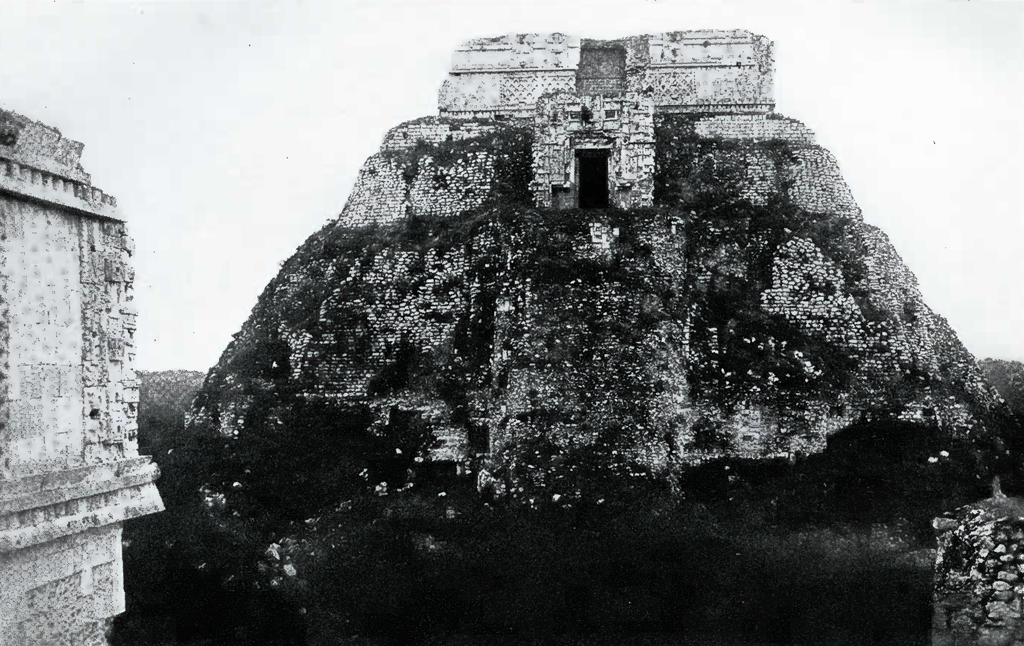
At 2.18 we arrived at Uxmal, which is situated in a rolling broken country running almost due north and south as far as the eye can see. This great city is a splendid sight from above. The. House of the Dwarf and House of the Governor show up splendidly, and the Doves and high truncated pyramids near by are far more impressive than when seen from the ground. Moreover, from the air many smaller ruins and mounds are visible in the surrounding scrub which apparently have neither been discovered nor described.
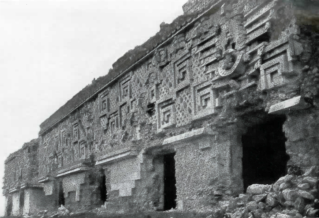
A large “aguada,” or water hole, lies about a mile away to the west of the House of the Dwarf, and several pools of water and ” cenotes” (or natural welli) about a quarter of a mile south of the Nunnery quadrangle, evidently the chief sources of water supply of the ancient inhabitants. The plane circled around this site several times and we obtained some excellent photographs from various directions, although the ruins were usually under shadows of clouds. [Plate 14.] The House of the Dwarf, which is 100 feet high, and the House of the Governor, which is 320 feet long, as photographed from land on another visit, are shown in Plates 15 and 16 to illustrate some of the details of Maya art and architecture. The great square group of buildings called “The Nunnery” which is believed to have been the home of the vestal virgins, has been carefully studied, measured, and photographed by an expedition from Tulane University under Mr. Frans Blom, and these beautiful examples of early American art will be reproduced in their original construction and color at the World’s Fair in Chicago in 1933.15
About 2.25 the plane left Uxmal (which is placed nearly half a mile too far east on the existing maps), and flew southeast over very broken country with low hills and ridges showing far ahead. Another range of low hills ran almost due south. In less than five minutes we arrived at Kabah, having seen many small ruins en route. Several photographs were taken of this city whose four large buildings were strikingly visible in the clearing around them. [Plate 17.] The country ahead was very broken and lumpy so that it was hard to tell from the air the difference between real and artificial mounds. A few minutes after leaving Kabah we reached and photographed Labna, which has a very impressive pyramid with an extremely high roof comb, and a large building with many doors. Like Uxmal and Kabah this site also has been cleared out by the Mexican government, and its ruins stand out sharply from the heavy forest surrounding them. [Plate 18.]
At 2.41 the plane left Labna and started southeast toward Lake Chichan-canab, which, as shown on existing maps, lies in the very center of the peninsula of Yucatan. The Lindbergh-Carnegie Institution flight of 1929 missed this lake, but found another one south and a little east of the map location of Chichancanab which the natives called Payegua. It was our hope to locate Chichancanab, which from the maps appears to be at least ten miles long, and to examine it carefully for ruins. Only one site — Elemax — is shown on any maps to be situated on its shores. Except for cloud shadows, the visibility was very good and the country below, at this time, was a mass of broken hills and full of small ruins, all probably well known and not worth photographing from the air.
Fifteen minutes southeast of Labna the country was still broken, but the elevations were much lower. A lake far to the left, or northeast, was dimly visible. By 3.10, or about fifty miles southeast from Labna, the broken country had disappeared• and the land ahead was nearly flat. In a few minutes more the plane was over what appeared to be a very large lake which had long ago dried up. Low vegetation could be seen on the bottom levels, and small elevations covered with higher trees rising here and there from this low-lying area were probably islands in the past when the lake was full.
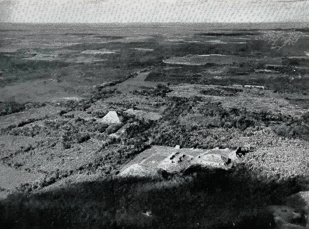
Image Number: 19021
is nearly all flat, low-lying ground, and from above, it is evident at once that the whole region slopes south and east toward the sea near Bacalar. According to the Carnegie Institution observers, for many miles to the north the country is apparently of the same general character, except that there are fewer dried up water courses and many more ponds and lakes.16 From the number of large dried up water courses in this area, it is likely that in the past, possibly during the time of the Maya civilization, the country was even more swampy than it is today. As it is uninhabited at the present time and as no signs of ruins were seen, it seems probable that during the rainy season most of this region has always been so wet as to be unfit for human habitation.
It is a curious fact that the Maya peoples very seldom erected any cities on or near the shores of lakes, Coba, Elemax and Muyil in Yucatan, and Yaxha and one or two others in the southern area, being notable exceptions. The sites erected on the edges of rivers are also few, the overwhelming number of the Maya cities being found in regions where the people must have relied upon artificial reservoirs for their water. Whether or not their aversion to the shores of lakes and rivers was due to fear of floods or based on a religious belief in the sanctity of rain water, are unsolved problems today. Perhaps both elements played a part, but in any event, our expedition further confirmed the general belief that it is hardly worth while to search for large ruins near the shores of any good sized body of water in the Maya area. We saw none in the lake area of Central Yucatan.
This region of flat low-lying land and dried up river beds and lakes interspersed with various ponds and swamps continued for perhaps thirty miles west-southwest from the new lake, until about 4.10. At this time the country below showed several long ridges or escarpments running nearly north and south and in the distance ahead there appeared the same broken country which was found around Uxmal. For the last one and a half flying hours, or at least a hundred and fifty land miles of distance with a lateral visibility of an average of perhaps thirty miles, not a sign of human life, not one thatched hut or single little clearing, was seen in the area visible from the plane, which must have been between 4500 and 5000 square miles.
At 4.20 the plane was once more over the broken hilly country in the west. This band of rolling ridges and hills running down the peninsula from the north continued as far south as could be seen from an altitude of 3000 feet. At 4.23 we passed just to the south of, and perhaps three miles away, from a small ” aguada ” near which were several very suspicious looking mounds. Their shape seemed artificial, with light patches on them which might have been stone work. Unfortunately, as already pointed out, the long search for Lake Chichancanab had taken most of our gasoline and consequently no detour could be made to examine these interesting elevations.
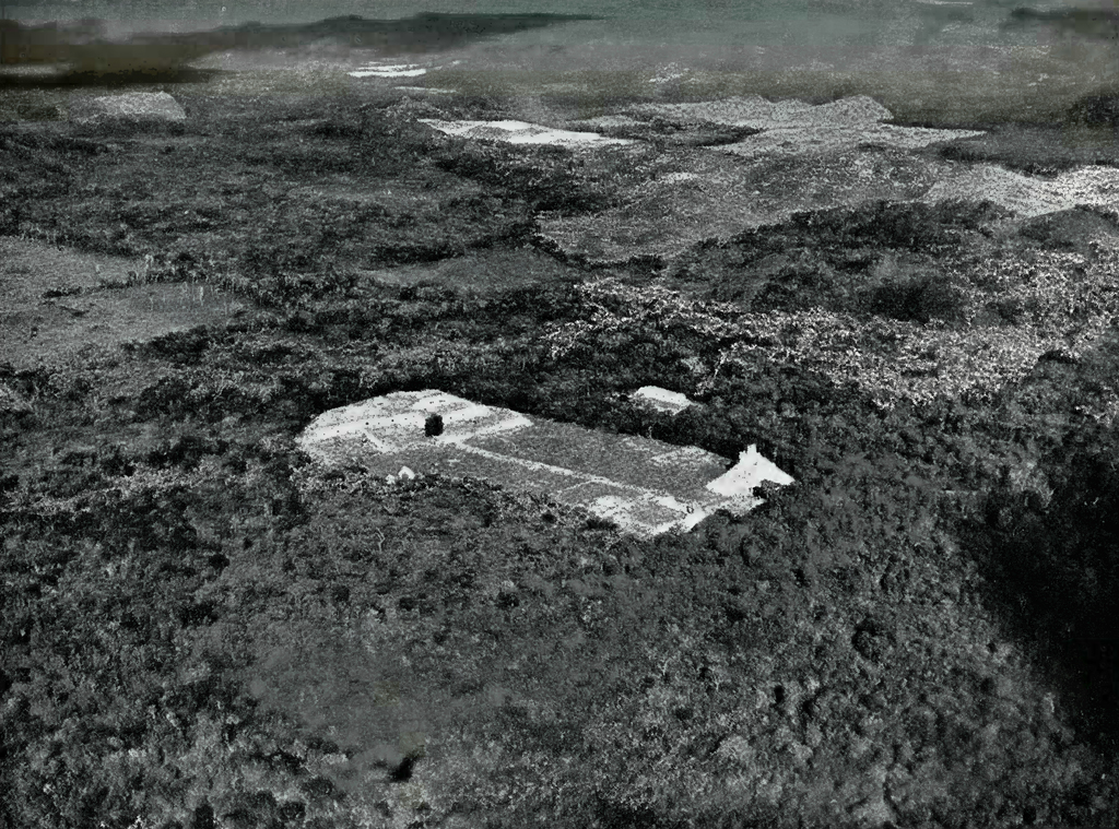
Image Number: 19023
Ten minutes later we passed to the north of and about five miles away from another group of mounds, two of which resembled enormous flat topped pyramids covered with vegetation. The country here was very broken and these may or may not have been natural hillocks. Five minutes farther on a clearing and a small road were plainly visible, the first sign of habitation or human life seen since leaving Labna. The ridges and hills in this region near the road and clearing were full of steep mounds toward the south but we could not investigate them and it is possible that some of them were large ruins. Many ruined sites are marked in this general area on the Blom-Ricketson-Spinden maps.
At 4.50 the plane passed just south of a town on a clearing near a small lake and at 5 P. M. was between a lake to the north with an island and an Indian settlement of several huts on its west side, and a long narrow lake or swamp to the south with still another shallow body of water beyond. According to later information the island in the lake may have been Isla Sagrada and the settlement the village of Silbituk, but this is not certain, as if so, these places are very much nearer the shore of the Laguna de Terminos than their positions on the maps indicate. At 5.10 the blue salt water of the Laguna de Terminos appeared far ahead — a most welcome sight — and an Indian village in a good sized clearing was visible to the north. A few minutes later it began to rain hard a short distance away to the south of our course. In the southwest the sun was low on the horizon, and shining through the rain made a wonderful golden veil hanging far across the skyline and trimmed with beautiful fringes of purple and amber and white.
At 5.27 we reached the lagoon a little way north of the mouth of the Mamantel River. From this point the Laguna de Terminos is apparently about forty-six miles across to Carmen instead of nearly fifty-two miles as shown on the Blom-Ricketson-Spinden maps. At 5.56 the plane landed at the Carmen field, having covered on this trip approximately 386 land miles in just under four hours flying time.
Mr. Moore, resident manager of the Hearst concessions in Campeche, and Mr. Shumacker, manager of the Campeche holdings of the Laguna Corporation, a chicle company, both friends of Dr. J. Alden Mason, met us at the field and took us in their cars to hotels at Carmen. The port of Carmen is the gateway for all traffic in mahogany, cedar, logwood and chicle coming down the rivers flowing into the Laguna de Terminos. This little town of perhaps 7500 inhabitants supports a few trolley cars which apparently are named after the lady loves of the officials, as the paint on the ladies’ names on the sides of the cars is much fresher than that on the rest of the surface. The streets are narrow and the natives drive their motor cars so badly that after several narrow escapes we all longed to be back in a good, safe airplane. The bridge over a little stream between the airport and the town cracked badly some time ago. Instead of repairing it, which would cost money, a soldier has been posted to compel all passengers in vehicles to get out and cross on foot, and the vehicles to follow them at a snail’s pace.
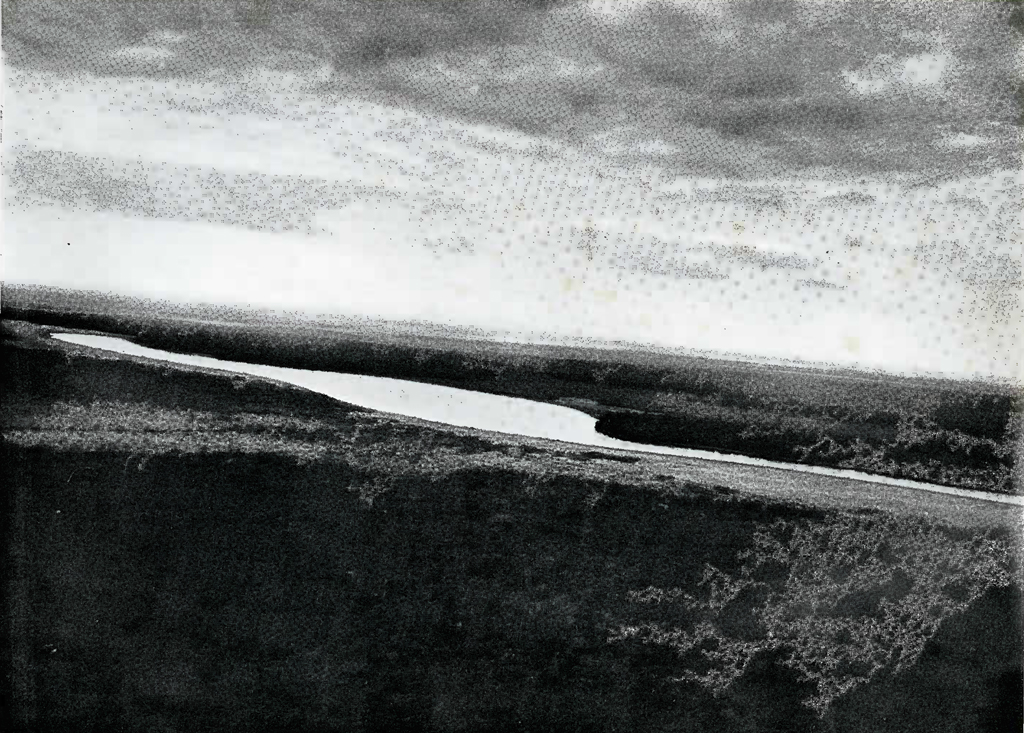
Image Number: 19029
On Wednesday morning, December 6th, the plane left the Carmen airport at nine o’clock for the valley of the Usumacinta River and by 9.15 had crossed the lagoon headed south-southeast toward Tenosique. During the next twenty minutes the country below was full of swamps and marshes with sparse vegetation and scattered low clumps of trees. Two deer were started up by the plane in this area and a few minutes later a small flock of large pink-colored birds which were either reddish egrets or pink flamingoes. The thirty miles of country southeast from the edge of the lagoon is so low and swampy as to be almost uninhabitable for any large number of people, and it seems unlikely that any important ruins will be found in this region.
Santa Ana, at the intersection of the San Pedro and the Usumacinta rivers, was reached at 9.45. Captain Ormsbee landed the plane very skil-fully on the latter river, after forty-five minutes flying time from Carmen. The anchor was dropped and Dr. Mason went ashore in a dugout canoe which worked its way out to the plane with difficulty on account of the swift current, flowing at about ten miles an hour. Dr. Mason’s visit was for the purpose of inspecting some equipment he had purchased in connection with the Museum’s expedition to Piedras Negras farther up the river. He was ashore nearly two hours on this mission. In the meantime the rest of us stayed in the plane, Mr. Smith fishing in the muddy water off the stern with no success. From time to time heavy logs came down the river moving very fast in the rapid current. Finally one of them struck the right forward pontoon and dented it seriously but luckily just missed breaking it, as such an accident would have ended the expedition then and there.
At ten minutes of twelve the plane took off from the river and headed for Tenosique. For the next few minutes the country below was a series of swamps, marshes and creeks with a few scattered fields, and was practically uninhabited except along the river banks. The river here and lower down is a maze of bends and turns, which is remarkable in view of the swiftness of its current. [Plate 20.j At noon a slightly higher country covered with tropical jungle was reached and Tenosique was in sight dead ahead. A minute or two later we were over the town. The inhabitants, men, women and children, ran out and waved at the first airplane most of them had ever seen, while horses, mules, dogs, pigs and chickens ran frantically into the forest, terrified by the roar of the motors. At 12.06 we landed on the river just opposite the town, after one hour in the air from Carmen, covering in this time a distance which took Dr. Mason last year five days to travel in a river steamer.
Image Number: 19038
A number of dugout canoes, heavily laden with natives, came out to the plane after the anchor had been dropped in the fast flowing current. Two of these collided just off the stern of the plane and one upset, all its passengers falling into the swirling brown water. We were afraid that some of these poor natives could not swim and might drown before our eyes although there was nothing we could do to help them. The other dugout, however, somehow managed to rescue the upset passengers, although it was apparently overcrowded to start with, and the unfortunate owner of the capsized canoe saved himself by clinging to it and finally drifted ashore. A very good moving picture of this entire incident was taken, as the camera was trained on the dugouts just before the collision took place. Dr. Mason went ashore to meet another of his agents in charge of some other work for the Piedras Negras expedition and returned in about an hour and a half. The balance of the expedition did not feel inclined to risk the dangers of the dugouts, and dozed on the lower wing of the plane.
After considerable difficulty in getting up the anchor on account of the depth of the river and swiftness of the current, we finally left Tenosique at 1.55 for the upper reaches of the Usumacinta. Eight minutes later the plane was above the spot where the river breaks through the mountains to the plains and at 2.18 had reached the site of Piedras Negras, one of the most famous of all the First Empire cities, where the Museum’s expedition is now successfully settled. Unfortunately, these ruins could not be seen from the air on account of the thickness of the vegetation and the steepness of the sides of the river. [Plate 21.] No plane could land safely on this part of the Usu-macinta on account of the swift current, and even if it did come down successfully, it is doubtful if its anchor would hold. Moreover, the plane would probably be wrecked against the shore while the anchor was being lifted before taking off. It might, however, be possible to land safely a short distance above Piedras Negras during the dry season when the current is not so swift, if a ground party had previously constructed in the river strong moorings similar to those used by boats in harbors, which the plane could cast off at the exact moment it was ready to taxi away. This would save many days in the trip from Carmen to the site. The opinion of an expert pilot at the time and under the conditions of the proposed landing should be obtained before any final conclusion can be reached as to the possibilities of using a plane at this location.
From just south of Tenosique all the way up to Piedras Negras the river runs in a tremendously deep and narrow gorge between wild and broken limestone hills. The tropical forest on all sides was magnificent; everywhere great masses of flowering creepers and trees, larger, and of a much deeper green and denser foliage than the Yucatan jungle. Beyond the gorge to the northeast the flat delta region of the river stretched for nearly a. hundred miles to the sea. The grandeur of the setting beggars description. [Plate 22.]
At 2.42 we reached the extraordinarily shaped bend in the river at Yaxchilan (Menche) where the Usumacinta makes a turn as abrupt and sharp as the closed end of a hair pin. The gorge of the river continued to this site, but here its sides were much lower and flatter. The pilot dropped the plane well down until it was not more than 50 feet above the water, and the ends of the wings were about 75 feet from the vegetation on either side. At this level we flew completely around the whole bend of the river past the site of the large and well known ruins of Yaxchilan. [Plate 23.] The tropical vegetation, trees, vines and creepers, formed so dense a curtain that not a single portion of the ruins, or the slightest vestige of any masonry could be seen. Low elevations which might have been natural were plainly visible, but nothing which could be clearly identified as artificial structures, even when we knew exactly where they were, not more than a hundred and fifty feet away. This experience convinced all of us that it is nearly impossible to find from the air any new sites in a country of a broken and densely forested character.
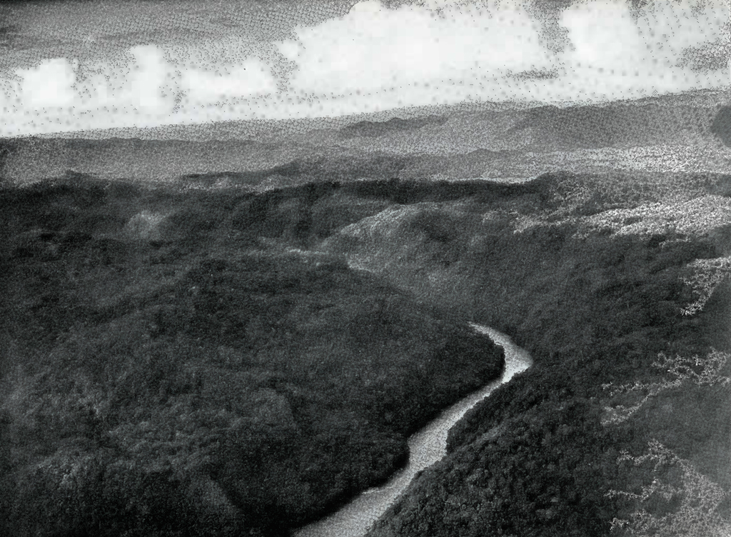
Image Number: 19050
At 2.45, having completed the flight around the bend of the river, the plane rose above the hills and started to find Lake Petha which was placed in several different locations on our maps. In about five minutes we passed south of a very large lake which must have been Lake Anaite, visible through intervals in the clouds surrounding us at that time. Ten minutes later fields and small ponds could be seen well to the south, and to the southwest the valley of another river almost parallel with the Usumacinta and ultimately running into it. Between 2.55 and 3.10 the plane flew over an extraordinarily broken and pitted country which resembled gigantic shell holes in a giant “No Man’s Land,” with patches of white limestone cliffs showing in many places through the tropical vegetation. For the most part, this wild and jagged region was covered with high green flowering trees, interlaced with vines and creepers of every description. Numerous small lakes were seen in this area and in the country to the northeast. All of this region is a blank space on the maps of the state of Chiapas, Mexico, and is commonly known as the land of the Lacadone Indians and also as El Desierto, or “The Desert.”
About 3.14 we arrived at a good-sized lake in the mountains which was almost certainly Lake Petha, as it was found in the position given for it on the Blom-Ricketson-Spinden maps. This body of water covered about a mile in each direction, with two long ends like fingers running to the northwest, which agrees with the description of Lake Petha. [Plate 24.] The plane flew very low, not more than a hundred feet above the lake or the surrounding shores, but we saw nothing resembling any ruins and only three native huts at the end of one of the finger-like bodies of water mentioned. No natives were seen; they had either deserted the huts or what is more likely, had run away into the jungle, frightened by the noise of our plane.
At a quarter past three the plane left and headed northeast for Palenque. Small ponds were all around, and more lakes in sight straight ahead. At 3.22 we came to another lovely lake in the midst of the mountains, larger than Lake Petha, with high cliffs here and there showing their white limestone sides through the dense tropical vegetation. No traces of ruins or any signs of native life were seen on its shores. The altimeter just above the water registered 4000 feet. Far to the west, high mountains showed clearly on the horizon. They appeared to be nearly 10,000 feet high and were possibly part of the Cordilleras. This beautiful lake is located at about 17 degrees 9 minutes north latitude and 91 degrees 46 minutes west longitude. As it is not now marked on any map, it is believed to be a new geographical discovery and was christened Laguna Margarita. [Plate 25.]
A few minutes after leaving this lake, we passed a river flowing north on which a good-sized waterfall was clearly visible, and at 3.55 came out of the mountains and foothills and were above the plains with the town of Monte Cristo visible to the northeast. The ruins of Palenque were still some distance away. Their exact location in the hills was not known to any of us, and the pilot sent word that we had very little gasoline so that it was necessary for us to head immediately for Carmen. Photographs of this part of the Usumacinta delta were taken. [Plate 26.]
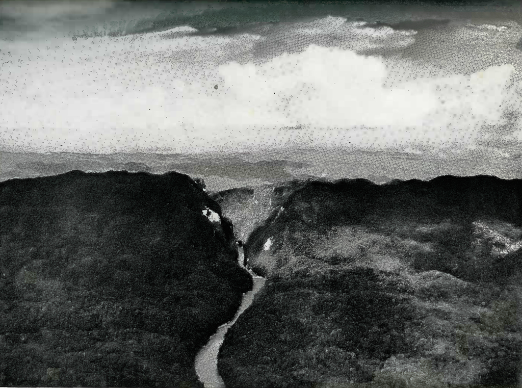
Image Number: 19047
While large Maya sites of the First, or southern Empire have been found quite extensively in the river valleys in the area we had just covered, none have been discovered high up in the mountains of this region. Here the Mayas seemed to have preferred the foothills or the flat plains. On the other hand, the lake country we had just traversed is so broken into sharp ridges and pinnacles that it may not be suitable for agriculture, as the soil in cultivated places would probably wash off rapidly from the steep slopes in the rainy season. This supposition is strengthened by the fact that only three Indian huts and no fields were seen in the entire distance from Yaxchilan to Lake Petha and thence to the end of the foothills near Palenque, which included seventy minutes flying time, or a distance of about a hundred miles; and, with a visibility of fifteen miles on each side, covered an observed area of nearly 3000 square miles. No part of this region is marked on any map, and it is all apparently hitherto unexplored and unknown country.
On the way back to Carmen we enjoyed a most unusual and extraordinary sight. The sun was low down in the western sky and the plane flying at an altitude of about 4000 feet so that the sun and the plane were almost on the same level. A rain squall came up to the right and, as the plane was in the center of the cone of the sun’s rays, the sunlight formed a perfect circular bow on the falling rain. From its top to its base, which was well above the ground, and thence back to the beginning the tremendous circle of the iridescent rainbow hung in midair in wonderful shades of blue and crimson and gold. The plane finally landed at Carmen at 4.50, having flown three hours from Tenosique and one hour in the morning before reaching that town, or a total of four hours in the air for the day.
After dark some of us wandered around Carmen. The white coral beach and the sea were dazzling in the light of a brilliant full moon and the stillness was broken only by the splash of the little waves on the sandy shore and the sea breeze rustling in the fronds of the coconut palms. In the tropics, the stars seem closer to the earth than in the north and twinkle and shine with a brighter and softer luster.
That night Mr. and Mrs. Schumaker entertained Mr. and Mrs. Moore and our party at dinner. Afterwards, we discussed with Messrs. Moore and Schumaker, who are familiar with all this region, the most desirable country to examine in the future for unknown ruined cities. Both of them agreed that the most likely territory was in the southeastern part of the state of Campeche, near the source of the north fork of the Candelaria River, close to the Guatemalan border. It is interesting to note that their opinions on this subject coincided closely with the location of the new large ruins reported to us by the Mexican government forester, in Merida.
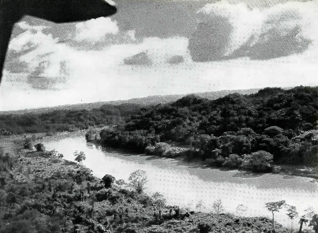
Image Number: 19061
We rose early the next morning, December 7th, intending to visit and photograph the ruins of Palenque, one of the most famous of all the Maya cities. Not long after we had started, however, masses of mist came down from the mountains and made it impossible to see more than a little way ahead. It was obviously unsafe to fly toward high hills under such conditions and it was equally clear that so long as the mist lasted there was no chance of finding Palenque, so we reluctantly returned to the Carmen field, and, after taking on a full load of gasoline, left for Belize in British Honduras, at 10.50 A. M. The course was laid on a bearing of 120° straight across the base of the peninsula of Yucatan; a journey which as far as is known had never been made before. It •covered country much of which had never been seen from air or land by white men, and we were very hopeful of finding something new, interesting, and important.
At 11.05 the plane had reached the land perhaps fifteen miles south of the mouth of the Candelaria River. To the east, the country was very flat and swampy with the Candelaria River winding in all directions. This low country continued for the next forty miles inland and appeared to be the same to the north and south of our course. It seems unlikely that any important ruins will be located in this area, the country being so wet and low as to appear unsuitable for any large number of people, but allowance must be made for the fact that we saw it just at the end of the rainy season. From time to time between 11.05 and 11.30 we passed small scattered groups of Indian huts along the banks of the Candelaria River, never more than six or eight thatched roofs in any one settlement, some of which may be chiclero camps. About 11.30 when we were perhaps forty miles inland from the sea, the country began very gradually to rise. At that time a few low hills or ridges were visible around us, and occasional swamps in the valleys between them. A lake, about two miles long, running nearly east and west, lay perhaps four miles to the south, with marshes around its borders. The rest of the terrain at this time was covered with jungle as far as the eye could see. At 11.40 we were between the Candelaria and another river to the south, either the south fork of the Candelaria or possibly the Chumpan. The visibility was poor, the cloud level at about 1500 feet, and the plane flying at about 1100 feet altitude.
Five minutes later both rivers had disappeared, although according to the maps one or the other of them should have been visible. In all probability the river courses on maps of this part of the country are drawn entirely by guesswork and are meaningless, although it is possible the rivers had become so narrow by this time that the jungle obscured them. At 11.47 a clearing with eight thatched huts was directly below and a good sized pond or lake with two islands in it was visible to the north. The lake was perhaps one mile long, running north and south and the Indian or chiclero huts a little way off from the shores. Swamps and meadows were now very few and the trees and vegetation were nearly solid.
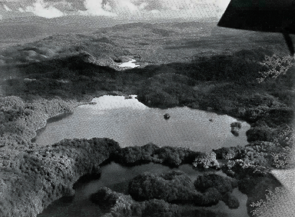
Image Number: 19064
At 11.50 small clearings showed dead ahead and to the right and left; the region below being still fairly flat but with low hills or ridges perhaps ten miles to the north, and about fifteen miles to the south. The country was rising gently along our course to the east and we were flying at about 2000 feet, just under the cloud line. What looked like the cone of a volcano appeared on the skyline far, far ahead and a little to the south of our course, which was altered so that we headed for it. The elevation was so large and so distant that we feared it would prove to be a natural mound. At 12.02 and again at 12.05 we passed over small rivers or streams, and at 12.10 were at the mound we had seen twenty minutes or so before, or at least thirty miles away. This big mound turned out to be the largest of a group of four artificial elevations, almost at the summit of a ridge. Viewed from the northwest, a smaller mound rose immediately in front and a little to the right of the large elevation, and two others slightly larger than the second mound were still nearer us, one directly in line west from the big mound, and the other more to the south. [Plate 27.] We circled around these ruins and took several photographs of the large mound. Masonry was clearly seen in several places, and there is little doubt that this is the site of a really important new ruined city. The bush covered summit of the largest mound towered far above the treetops, which here were at least a hundred feet high. At a conservative estimate, the top of the largest ruin must be one hundred and fifty feet above the level of the surrounding country and the other three mounds are possibly two thirds of that height. The size of the largest mound puts it in the class of the great temples of Tikal, the largest and one of the oldest of the Maya cities, which is not more than forty miles away from this site.
While circling around these ruins, which we later estimated to be at 89 degrees 50 minutes west longitude and 17 degrees 40 minutes north latitude, we saw another high mound with a smaller pyramid behind it, near the top of a different ridge about seven miles to the south. We flew over to these elevations, which were at about 89 degrees 50 minutes west longitude and 17 degrees 32 minutes north latitude. This second site consisted of a high pyramid, to the northeast of which was a lesser one, and to the south and east a group of low mounds. [Plate 28.] It was impossible to decide whether or not these low mounds were artificial. Masonry was visible, however, near the top of the large ruin in this second group, which likewise was photographed.
These two sites are both on the northwestern slopes of two ridges running nearly northeast and southwest. The approach to them from the west is over flat country gradually rising toward the ridges. No clearings, water holes, trails or openings in the vegetation were seen in any direction from either of these sites, and it would be very difficult to land anywhere near either of them in this country today. The rivers seen a little while before the first and largest group was reached are probably too narrow and the jungle covering them too thick for any plane to use for landing, although they might possibly be used by an autogiro equipped with pontoons. It may, also,’ be possible to approach within a few miles of these ruins by canoes coming up the Candelaria river.
After looking in vain for signs of other ruins, we left for Belize at about 12.25, and in a few minutes were over much more broken country, full of ridges and low hills like the region of northern Yucatan around Uxmal, and which appears to be a continuation of this same formation. At about 12.45 we were fairly well out of this broken country, which, including an area of low ridges on both sides, seems to be sixty to seventy miles wide in this region. A small river running north and south was visible at this time as well as a large clearing with clumps of trees and patches of sand showing plainly from the air. The vegetation soon became less dense and the country much flatter, meadows appeared far ahead and low hills to the northeast. From here on the plane rose to an altitude of 7000 feet in order to obtain a favorable wind and at 12.55 was above open patches of country. All along the horizon to south and east the clouds were massed at a level well below us, like an enormous snow field on the top of a mountain continuing as far as the eye could see.
At one o’clock the plane was over a large swampy area with a river in sight ahead of us. A wireless was sent from the plane to the New York Times reporting the discovery of the two new sites. At 1.05 we reached the junction of Laboring Creek and Old River, forming the Belize River. Mountains or high hills showed on the horizon far to the south. Five minutes later three large mounds were plainly visible, about fifteen miles to the northeast; probably the ruins marked New Boston on the Blom-Ricketson-Spinden maps. The country beneath and ahead was low and marshy with creeks and rivers winding in all directions. At 1.23 we were over the town of Belize, with its colored roofs and houses looking very picturesque from the air, and in two minutes more landed on the sea in front of the wooden ramp of the Pan-American Airways’ station, after two hours and thirty-five minutes flying time from Carmen, over a distance of approximately two hundred and fifty land miles.
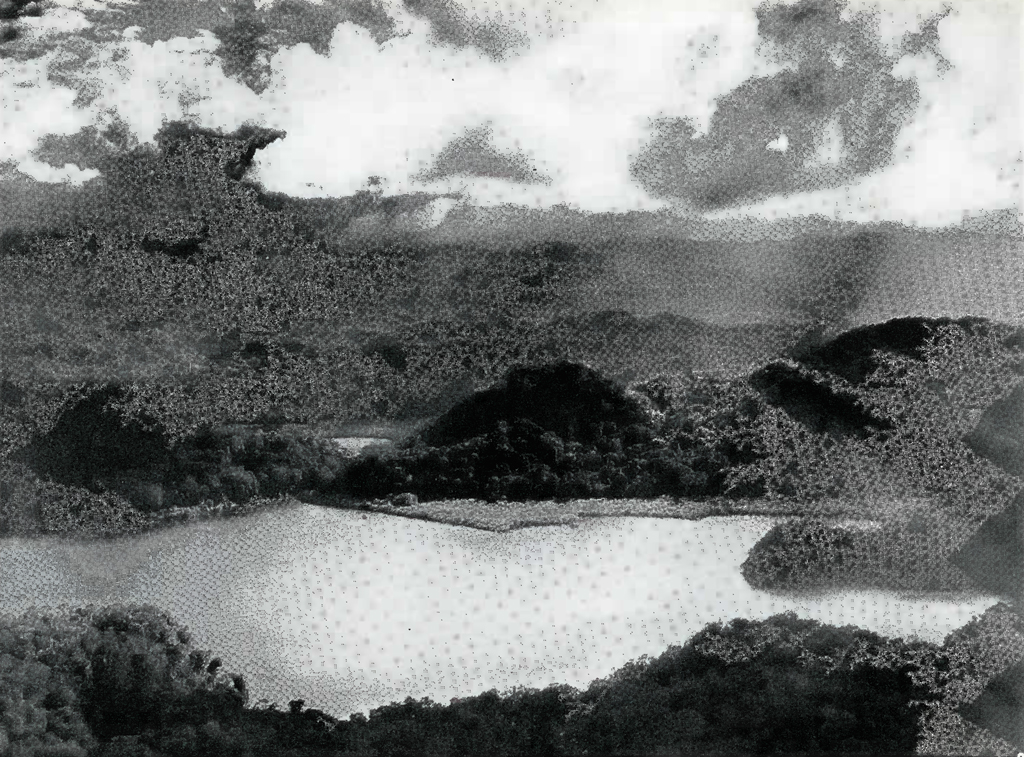
Image Number: 19066
Mr. Masson, Belize Manager of the Pan American Airways Company, met us at the ramp with telegrams, letters and clippings from the American papers. Our baggage was given a perfunctory examination through the courtesy of the local officials, and we then went to the Palace Hotel where we found the accommodations were the best since leaving Havana, with the single exception of Merida. After lunch at about three o’clock, we decided not to take the plane out the next day, but to rest and work out our plans for the remainder of the trip while the motors were being overhauled. We had very little remaining flying time after making allowance for the amount necessary to return to Miami, so that it was impossible to take a trip south to Copan and Quirigua. These two well-known sites, however, apparently have no suitable places in which a plane could land and are reported to be not well cleared of vegetation. If so they would not show up from the air sufficiently distinctly for worthwhile aerial photographs.
After dinner that evening we called on Mr. P. W. Schufeldt, a prominent chicle contractor and one of the leading citizens of Belize, who has a vast amount of information about Maya ruins in British Honduras and North Guatemala. We spent several pleasant hours ‘at his house and met the Port Quarantine officer, who very courteously expedited the quarantine regulations for all of us. Mr. Schufeldt also believed that southeastern Campeche and the extreme northern and northwestern parts of Guatemala were now the most likely places in which to find new and large Maya ruins. He suggested that the two ruins we had discovered that day might be two shown on the Blom-Ricketson-Spinden map in that vicinity, but added that as far as he knew, they had never been seen except perhaps by native chicle gatherers, by whom their mere existence had been reported and their map positions made by guess. Later on, after our return to the United States, Mr. Frans Blom, of Tulane University, confirmed these statements after examining his data on the above maps. These two sites are therefore new scientific discoveries, having been located, described and photographed for the first time.
On. December 8th, after breakfast we wrote up our notes, and later on the writer, Mr. Gregory Mason and Dr. Alden Mason again visited Mr. Schufeldt. As the result of our conference with the latter, and a study of the maps we decided that the Yaxha Lakes were the only available place near ruins worth examining which might be reached within a reasonable time by using the plane. We found that Tzibanche, the site we had originally thought of visiting in Quintana Roo, probably could not be reached from Lake Bacalar, as it is separated from it by one or two deep “bajos” or swamps, which at this time of year would be full of water.
In addition to ruins on the Yaxha Lakes which have not hitherto been well investigated, Mr. Schufeldt told us of a site called El Gallo, about twelve miles inland from the lakes near a place called San Clemente, which he thought would well repay a visit. He very kindly pointed out certain difficulties in visiting this site at this particular time, however, saying that it was so soon after the end of the rainy season that the trails might be impassable on account of the mud, and that no men or animals might be available at the village on the Yaxha Lakes as the chicle was still coming out from that country. At the end of the discussion, we finally decided to go to Yaxha as these lakes were but an hour away by plane, and to be guided on arriving by the situation found on the ground. In the afternoon, the writer, Dr. Mason and Mr. Gregory Mason called on Sir John Burdon, the Governor of British Honduras. We were most cordially received and learned a great deal about the past history of this interesting colony, of which Belize, a city of about 12,500 people, mostly negroes, is the capital and seaport. Its principal industries are fishing, exporting hardwood and chicle, and last but by no means least, rum-running to the United States.
On December 9th we left Belize about 7.11 and headed for Yaxha, which is a little to the south and west. For the first ten minutes the plane passed over a swampy area followed by low ridges but by 7.22 we were above a mass of high steep-sided hills with white patches of mist streaming up from their peaks like veils of smoke. This range was about 1000 feet high and was everywhere completely covered with vegetation. It continued below for the next twenty-five miles and appeared to run from south-southwest to north-northeast. At about 7.45 the peaks were nearly 1500 feet high and the plane was flying in and out of masses of clouds only a few hundred feet above the summits. It was impossible to go much lower on account of the danger of running into a hillside and it seemed possible that we would not be able to find the lakes on account of the low lying clouds, as we could only occasionally see the country below us. Five minutes later the plane crossed a branch of the Belize River, and in a few more minutes the clouds became thinner and the mountains lower. At eight o’clock the Yaxha Lakes were sighted dead ahead, consisting of two large bodies of water close together. Either one large or two other smaller lakes were visible farther off to the west. In a few minutes more the plane circled over the more westerly of the twin lakes, which are at an altitude of 600 feet above sea level, and then dove down to the water and skimmed across its surface to the shore at the native village of Yaxha. [Plate 29.] The Lindbergh-Carnegie Institution flight landed on this same lake in 1929, so some of the Indians had already seen an airplane at close range. The trip from Belize covering eighty-two land miles was made in fifty-four minutes in the air; a journey which takes five to six days by boat and mule.
The native village consisted of about twenty thatched huts on or near a neck of land between the two largest lakes and contained fifty or sixty inhabitants, mostly women and children, as well as several pigs and dogs, all of whom were at the water’s edge to meet us. The pilot taxied the plane until it almost touched the land, and then threw a rope to a native. The latter came out along it hand over hand standing in a dugout canoe and our party then went ashore in the same way. After a good deal of difficulty and much discussion about the El Gallo ruins, we finally succeeded in hiring a very decrepit horse and two men to accompany us to that site. Later we obtained another man and a mule, which enabled us to have all our baggage transported on animals. Our schedule was written out and given to Captain Ormsbee, calling for his return to the lake in three more days at noon. The plane then taxied away while Gregory Mason took moving pictures of it, rose beautifully in the air, and finally disappeared in the center of a cloud about 1500 feet up and directly over our heads.
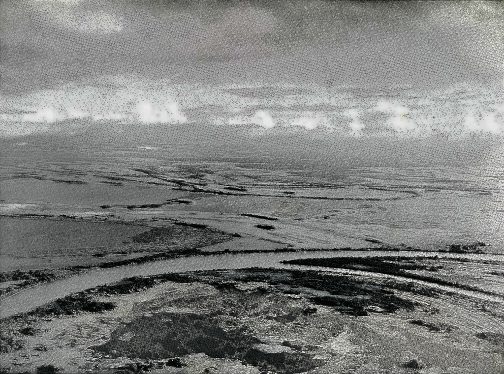
Image Number: 19068
After the plane left, some time was spent in making final arrangements about food and baggage. The natives refused to be hurried in any way although both Gregory and Alden Mason used their best efforts to get us off. At last the animals started ahead by land and the expedition and its baggage were put in two dugouts for a short voyage of three or four miles along the lake to where the trail to El Gallo intersected with its shore, thus saving us that much walking and the animals an equal amount of effort in carrying our baggage. Each canoe was paddled by a single Indian, and both were so heavily laden and so unsteady that it was necessary to lie almost flat on the bottom in order to maintain any sort of balance. The Indian paddlers cheered us with the assurance that the lake was full of alligators which were very fond of men, but we accepted this rather startling information as the usual attempt of all local inhabitants to impress strangers with the difficulties and dangers of their country and their work.
About an hour after starting, we reached a little creek running up from the lake and intersecting with the trail from the Yaxha Lakes to the ruins. It was very hot. At a little before noon, the thermometer in the sun registered 106° F. When the animals arrived they were swum across the creek which at this point was about fifty yards wide, then repacked, and the start for the ruins was made at 12.20. From then on, at intervals of almost exactly one hour, we came upon a series of camps of the chicle gatherers or ” chicleros.” These camps are thatched lean-tos in clearings along the trail where the mule trains spend the night wherever it overtakes them on their long trips. They are usually placed as near as possible to a convenient water hole and, with this qualification, are a “league” apart. A chiclero’s “league” is the distance which a loaded mule will travel in one hour, and may be two and a half, two and three quarters, or three miles. The distance that a mule will travel in a day is called a “jornada ” and, varying with the nature of the trail, the country, the mule and the chiclero, is anywhere from ten to twenty miles. The language applied by the mule drivers to the animals sounded very familiar both in tone and in emphasis. A free translation given by one of our party conversant with the subject showed that the Indians of North Guatemala were applying to their mules the identical epithets used by American mule-skinners to the same kind of animals. Evidently the Guatemalan mule moves best only under the same sort of persuasion as is needed for the Missouri variety.
The trail we followed runs from Flores to British Honduras and is the principal highway in the Peten district of North Guatemala. It is in no sense a road, but a mule path cut through the jungle, very rough and in spots exceedingly muddy. In many places it was a series of alternating humps and hollows worn about a foot deep by the feet of many mules sliding down into what were at first only small depressions. The route ran through typical forest country. Great mahogany, cedar, ceiba, ramon and sapote trees towered from a hundred to a hundred and twenty-five feet in the air, interspersed with numerous cuhoon palms whose fronds were as much as thirty feet long, with each leaf or blade running eight to ten feet in length from the parent stem. The jungle on both sides of the trail was choked with vegetation and the air was hot and very moist. We finally reached the thatched chicle huts which were to be our base at five o’clock, a journey of twelve miles from the ford, or six hours in all from the Yaxha Lake settlement. We unpacked and made camp immediately upon arriving, as in that latitude it becomes dark by six o’clock and there is no twilight.
We prepared for the night by hanging our hammocks from the supports of the chicle huts, and surrounded them with mosquito netting, through which the ends of the hammocks were run, like an arm through a sleeve. In the writer’s opinion, at least for a tall person, the hammock cannot properly be regarded as a sleeping facility but merely consists of a more or less uncomfortable accommodation in which to spend the night off the ground. Our food that evening as well as during the rest of our stay in the forest consisted principally of canned soup with rice, Indian tortillas or corn cakes, beans, coffee, and a little preserved fruit.
The water in the near-by water hole was soon used up and we had to rely upon that found in the next nearest one, close to a large chicle camp about a mile away, in which the mules continually wallowed. Twice a day one of our men went there with the animals and canvas water bags. These water bags, however, carried so little water and the need of it for cooking and drinking was so great that none could be used for washing purposes. The water itself was very unpleasant, both in appearance and in smell. The natives had no idea of the meaning of the word “boil” in contrast with “cook,” so we could not rely upon them to heat the water long enough to sterilize it properly. Consequently, it was treated with succinchloramide tablets, which free chlorine when dissolved in water. Hot water saturated with chlorine was all we had for our canteens and in that climate it never became really cool.
On December 10th after a very early breakfast, we left a little after sunrise with our guides for the ruins which were perhaps half a mile from camp. The approach was by a woods trail made by chicle gatherers looking for ramon trees, whose leaves and nuts constitute the principal fodder for their mules, as no grass grows in the jungle. The bush here was very thick, with lofty trees, dense underbrush, and creepers and vines closing in from every side. The howler monkeys were still calling at this early hour and the uncanny maniac laugh of the chachalaca bird occasionally shattered the silence. Countless other lovely birds, and beautiful butterflies of every description filled the air.
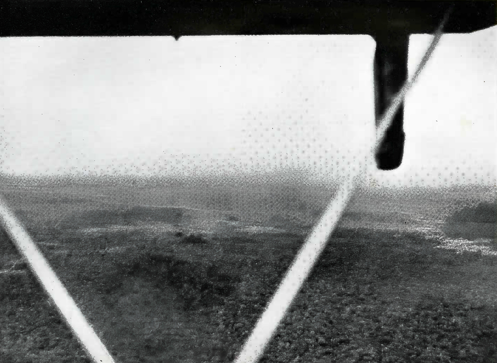
The first ruin reached was a mound about 125 feet long and perhaps 20 feet high and 25 feet wide at the top, with no signs of masonry. We then climbed about 20 feet up the steep side of a ruined terrace fifty yards east of this mound and abruptly came to twin temples perhaps 50 feet apart, which towered high above a mass of debris at their feet. The sloping bases of these towers were each about 25 feet high and the masonry walls ran sheer up from the tops of these bases 35 feet or more into the air to the remains of ruined rooms at their summit. The western temple showed a cornice on which ornamented stone work was plainly visible. [Plate 30.] On the north side of each of the towers were the remains of what had once been very steep stairways running 65 feet up from a lower plaza to the temples on their tops.
About a hundred yards to the north of these twin temples, at the opposite side of a lower plaza we came upon the jungle-hidden ruins of an enormous structure built around two levels in the form of a rectangle open at the eastern end. The south wing of this building was about 220 feet long, the west one nearly 100 feet in length and the north wing a little shorter. The west and north wings of the building showed 20 feet or more of clear masonry wall rising through the forest from masses of debris which sloped steeply 60 feet or more down to the general level of the surrounding country. [Plate 31.]
After a hurried inspection of these buildings, we studied the formation of the entire site, which could be divided into three distinct parts. (1) The rectangular building to the north, opening directly to the east, which included an upper and lower court connected by a ruined stairway 15 feet high and which may be called the northern plaza. (2) Fifteen feet below the level of the lower court of the north plaza, the main plaza ran due south to the base of the twin temples and contained two long mounds in the middle and three on the sides, also two stelae whose glyphs had been weathered away. (3) A third plaza extending south rose fifteen feet above the central plaza, the twin temples towering up through the trees at the intersection of the middle and southern plazas and facing squarely to the north. The site as a whole was clearly an acropolis on the summit of a natural bill which had been leveled off, and its long axis ran to the true north as accurately as if laid by compass. Their location and style of architecture identifies these ruins as characteristic of the First Empire, and in all probability they were built perhaps 1500 years ago. See plan of ruins, Plate 32.
This site is only a few miles away from Uaxactun, the oldest of the ancient Maya cities, and Tikal, the largest and one of the best preserved. Each of these has been visited and described by many archaeologists, and Uaxactun is now being cleared and excavated by Carnegie Institution under the direction of Mr. Oliver Ricketson, who has only recently uncovered by far the oldest known Maya structure.17
The next morning, December 11th, we found three stelae in the central plaza which we had missed the day before, one leaning forward with a perfectly clear under surface which was probably covered with painted hieroglyphics when it was erected. Unfortunately, the glyphs had disappeared and the surface was only smooth stucco. Round stone altars were discovered at the bases of the stairways leading up to each of the high temples, and various mounds in the south and central plazas which had been at first overlooked. The rectangular building on the north plaza was examined very carefully and found to contain six rooms in fairly good condition, and the remains of several others. A passage ran through the south wall of the northern structure where the upper and lower courts met, and in this passage a number of carvings of human figures with head dresses and spears were still visible on the stucco-covered walls. In one of the rooms of this large palace the marks of a human hand painted in red were clear and fresh after fifteen centuries, and in another room a wooden lintel with the bark clinging to it lay where it had been placed by the builders in those far off days — a striking evidence of the hardness of sapote wood. A number of fallen stelae in the central plaza and the two round altars by the temples were turned over, but nowhere on them, or on any of the buildings, was anything resembling a glyph. To the east of the twin temples a small lower plaza with parallel mounds on its east and west sides, and two stone covered barrows, or graves, beyond the eastern mound were a surprising new discovery.
Alter an enormous amount of cutting, chopping and hacking with our machetes we cleared away enough vegetation to measure the dimensions of the various plazas and ruins, and take numerous photographs of the principal features. This completed all that a preliminary survey could show and we returned to camp about 4.30. Rough sketches were made of the general plan of the site including the mounds and the graves found to the east of the central plaza, and two “chultuns” or underground storage receptacles discovered near the long high mound first seen. One of these chultuns was scarcely visible but the other was in excellent condition. It consisted of a hole in the surface about 3 feet in diameter leading down to two intersecting round chambers each about 5 feet high and 10 feet across, separated by a masonry wall, completely dry and in good condition.
It may be of general interest here to give a few comments on the jungle of this region, which is at an altitude of about 800 feet above the sea. In the great tropical rain forest of this part of north Guatemala the principal fauna include jaguars, peccaries, tapirs, black howler monkeys and ring-tailed monkeys. Great quantities of birds are everywhere, particularly shortly after sunrise, and include the wild turkey, curassow — a large black bird with yellow crest — many kinds of parrakeets, toucans, hawks, buzzards, herons, chachalacas, orioles and humming birds; and countless butterflies. No snakes were seen, although the Central American rattler or ” Cascabel,” and the Fer-de-lance or “Bothrops” are supposed to be fairly common, and the boa constrictor is occasionally encountered.
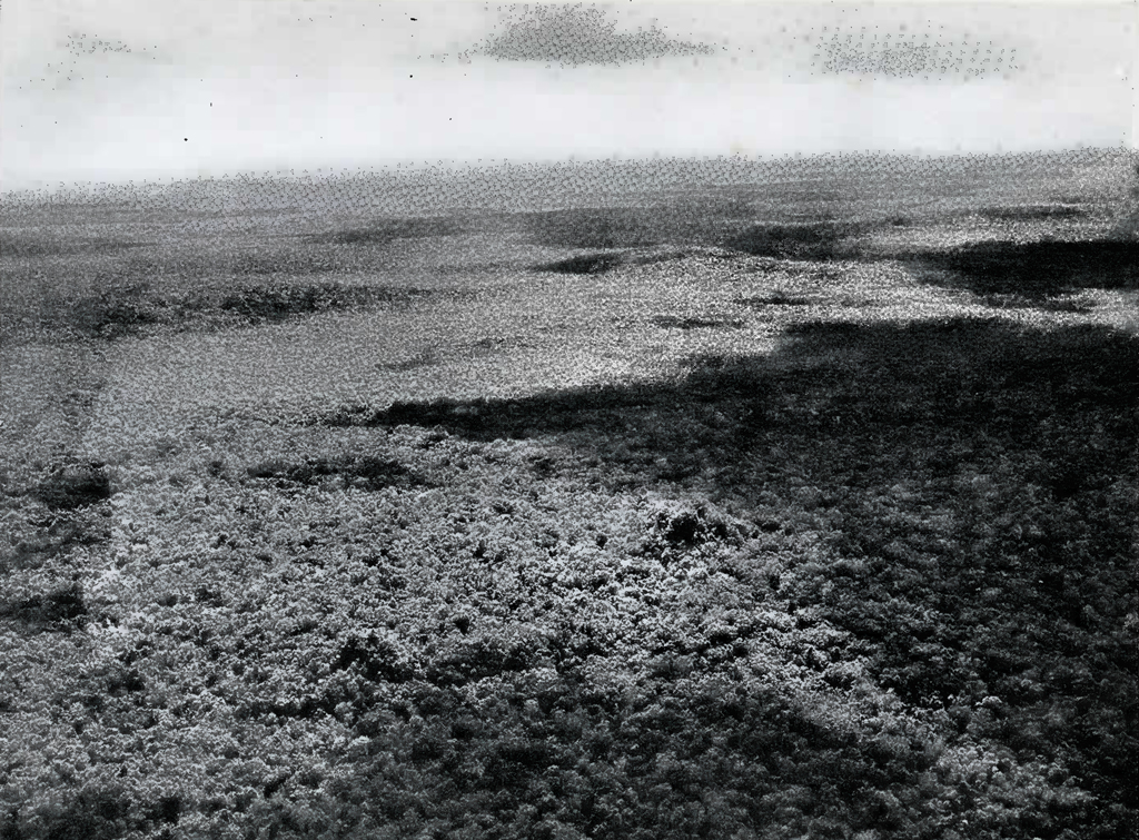
Image Number: 19078
The curse of the Central American forest is the insects. The only ones in the region which did not bite were the bees, which for some strange reason, are here without stings. Mosquitoes and flies were not particularly bothersome, but the red bugs and the small “garrapatas” or ticks which infested the vegetation were annoying beyond words. We were bitten incessantly by these pests, which are so small they are hard to see, and there is apparently no effective remedy or preventive. The bites itch and burn for several weeks in a hot climate. The natives seem to be much less troubled by all insects, possibly because they generally use neither sugar nor salt.
In the middle of the day, even in December, the thermometer runs up above 100° F. in the sun. The temperature in the shade is usually around 80 degrees, but accompanied by great humidity, making the air like that of a hothouse. Due to the massed vegetation there is never the slightest trace of a breeze. Of the three nights spent in the jungle, two were uncomfortably cold, below 60 degrees, the other about 70 degrees. Contrary to the ordinary opinion, there is no danger from the heat, as the tropical forest is not much hotter than many August days in Philadelphia, and sunstroke is unknown in Central America. The real hazards of travel off the beaten track are thirst and hunger and disease, but within the zone of cleared passages, and with ample supplies and proper care as to diet, water, and so forth, the wilderness is probably no more dangerous than the streets of a big city.
Even in the middle of the day the light is always dim and mysterious. The giant trees tower up over a hundred feet toward the sky, carrying with them great clusters of vines and creepers, which shut out the sun. The vegetation is so dense that it is impossible to see any distance through the close knit green curtain. The whole setting is sombre and depressing, the great forest giving man a terrific sensation of loneliness and of his utter insignificance amid the vast forces of nature. The web of the treetops blankets the sky, so no stars shine to light the night in the forest and soon after the sun sets the darkness drops in a solid wall. Later on, the unbroken jungle can become beautiful beyond words under a full moon. Its shimmering rays pour through the great trees and the masses of vines and creepers etching in silver and shadow an effect which cannot be described to those who have not been fortunate enough to see it. In full daylight, the great rain forest is silent, with a menacing, crouching stillness, but with the darkness, sounds of every description come and go, near by and far off, from the soft steps of land animals to the curious deep wailing roars of the black howler monkeys. Sometimes all sounds sink down and down until the faint noises of the wilderness at last die away in even lower murmurs, slowly fading beyond human hearing into the farther side of silence.
It is hard indeed to put into words the strange feeling of wonder which’ comes at the first glimpse of great forest-covered buildings of a civilization that passed away long ago. Mixed with this wonder is a consuming curiosity to find as soon as possible all the hidden secrets of the ruins and a profound hope that just ahead waits some new and important discovery never made before. The imagination strains itself to visualize the splendor of these structures in the days of their glory and the lives of the people who built them. It is these and many other kindred sensations that make field archaeology today perhaps the most fascinating of the sciences.
After an early start from camp in the cool of the morning of December 11th, we reached the Yaxha Lakes about noon, and were met there promptly by the plane. Captain Ormsbee, with his usual thoughtfulness, had brought us sandwiches and a large supply of beer on ice, which was most cordially appreciated as a wonderful change from hot chlorinated water. After quickly finishing the beer, we gave the ice to the natives who had never seen it before and who were quite at a loss to know what it was or what to do with it. After examining it carefully and passing it around, one of them tied up a piece in cloth for future preservation and departed to hide it for safe keeping. Two native boatmen were then persuaded to take a tow in their dugouts behind our plane while we photographed their trip. They were terrified by the thundering of the motors and the gale from the propellers, but held on to the free end of the rope throughout the ride, so they must have enjoyed it in their own strange way. The sight itself was full of interest — the primitive dugout canoes which have not changed for thousands of years hitched to perhaps the most finished product of the machine civilization of the North. A successful test was also made of the possibility of lowering supplies to a ground party by parachute from an airplane. The parachute was dropped from a height of about 500 feet and carried its load down so slowly that ordinary provisions or even moderately thick glass would not have been damaged at all.
After these performances were over, we paid off the men, gave them a lot of left-over food, shook hands all around in farewell, and left the Yaxha Lakes shortly after one o’clock. We flew toward the ruins on which we had spent two days hard work clearing away vegetation and which were not more than twelve miles away, but we could not find any trace of them from the air on account of the thickness of the forest. The plane then headed for Belize where it landed at 2.18. From the center of the north Guatemalan jungle with its ancient Maya ruins to the civilized city of Belize was an amazing transformation — like moving through a thousand years in fifty minutes.
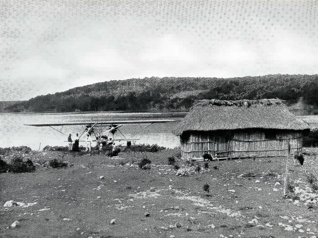
Image Number: 202712
Following a most welcome bath we again called on Mr. Schufeldt, and after some further investigations learned definitely what we had previously suspected. We found that the ruins we had visited were already known under the name of “San Clemente” and had been examined and charted by Messrs. Sapper, Morley and Blom, although none of them had made any detailed measurements or taken photographs of the buildings at the site. We did not observe any traces of a building reported by Sapper and Blom at the northeast corner of the north plaza, or of a large structure reported by him opposite its southeast corner. These are marked M1 on the Plan of ruins, Plate 32. We crossed this area several times and can only suppose that these ruins have been completely obliterated by the forest. We also did not see two stelae reported by these scientists to be just south of stelae 4 and 5 shown on the plan. On the other hand, we discovered a considerable number of interesting features in these ruins which had previously been overlooked. Our measurements, photographs, and the newly discovered material undoubtedly constitute a contribution to archaeological knowledge, and will no doubt be embodied later by Dr. Mason in a more formal monograph.
The next morning, December 13th, we left Belize at 7.05 heading about north-northwest. The weather was cloudy, as is usual in this latitude at that time in the morning during the winter season. At first the country below was a flat marshy plain, fairly well covered with vegetation. This is typical of most of the coastal region of British Honduras, which is so low and swampy as to appear unsuitable for human habitation. Ten minutes after leaving Belize, long low ridges appeared in the west about twenty-five miles away and running apparently almost due north. At half-past seven the country was full of hills and ridges with lakes and ponds scattered in all directions. The same long range of low hills still appeared on the western skyline. At 7.41 we crossed New River, which at this point is very winding, and three minutes later passed a good-sized “hacienda,” or plantation, with six or eight huts around it. What appeared to be the southern end of the Bacalar lagoon was visible about six miles away to the north, as well as a very prominent landmark in the form of a high whaleback ridge perhaps twenty-five miles away, to the northwest.
At 7.47 the Bacalar Lagoon showed up to the right and ahead of us, and three minutes later the plane crossed the Rio Hondo, just above an Indian village at the edge of a very dense jungle. The Rio Hondo near this Indian village appeared to be deep enough and straight enough for a plane to land on, but it may not be sufficiently wide. In any event, a water landing could be made within a comparatively short distance of this village, which is evidently Sac Chan, from which Dr. Gann made his start for the ruins of Tzi- banche, which he has described fully in a most interesting work.18 [Ruin III, Map.] At 8 o’clock the plane was over a wide valley full of water between ridges running north and south. Here we circled around four suspicious looking mounds on the eastern side of a long low ridge but saw no masonry, and could not determine whether they were natural hillocks or artificial elevations. The country here was very broken and full of small hillocks. The high whaleback ridge already mentioned was only a few miles away to the north. This was obviously the ridge referred to in the Carnegie Institution’s account of the flight with Lindbergh near which several new sites were found.19 It runs approximately north-northeast and south-southwest, and is about five miles long, and eight hundred feet high.
At 8.12 we circled another high mound on a lower prolongation of the whaleback ridge running to the southwest. From its shape and general appearance this mound was certainly artificial. Three other mounds were near by. We could see no masonry but believe that this mound was one of the temples of Tzibanche. According to the notes of the writer as well as those of the pilot, at about this time the plane was three miles southwest of the southern end of the ridge where a group of four distinct mounds were observed, one larger than the other three, which fits almost exactly with the description of Tzibanche from the air given by Messrs. Kidder and Ricketson of Carnegie Institution.20 We did not, however, observe the aguada and clearing which they noted at this site, and may be mistaken in our identification. If so, these mounds we examined may be another new ruined city in this area.
Owing to some mistaken instructions the pilot then took the plane away from this position toward the western side of the whaleback ridge and afterwards returned to its eastern side by a different route and. we did not again pick up the ruins of Tzibanche. At 8.18, however, we passed immediately above another group of three mounds which were almost certainly ruins, as their conical shapes were arranged accurately on the points of an equilateral triangle with a square cenote a little southwest of the base. [Ruin D, map.] These ruins are about three miles northeast of the northern end of the ridge and in a broken country. They are probably new, as they do not correspond with the description or the location of any of the other ruins found in the neighborhood of the whaleback ridge by the Carnegie Institution archaeologists, and they are not shown on any known archaeological maps.
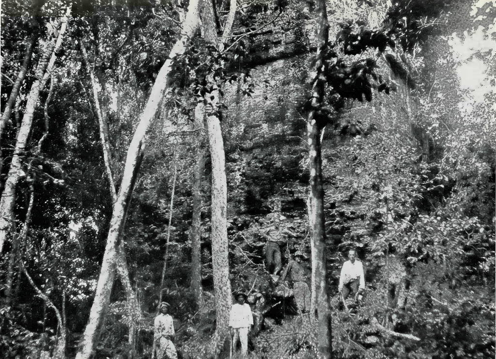
Judging from the mounds which the expedition investigated, the new site that it found, the known ruins of Tzibanche, and the two others in the vicinity reported by the Carnegie observers, this region of the whaleback ridge is certainly a most promising field for future archaeological investigation, It is apparently very difficult to reach it from Lake Bacalar, as the country between the ridge and the lake contains one or more deep valleys in which water was seen through the trees, and which are probably impassable to ground parties during most of the year. The best way to approach the ridge seems to be by way of the Indian village of Sac Chan on the Rio Hondo and thence by trail, probably a two days’ land trip, according to Dr. Gann’s account above mentioned. If arranged for ahead, men, mules and guides can probably be obtained at Sac Chan, which is about a two days’ voyage from Belize.
The center of whaleback ridge and the ruins of Tzibanche appear to be respectively ten and five miles north and about twenty miles west of the southern end of the Bacalar Lagoon.21 The other ruins reported are all only a few miles north of the site of Tzibanche and, although none were seen, it is quite likely that on or near the top part of the whaleback ridge some very large buildings will be found. It is known that the Maya were inclined wherever possible to build on the tops of hills overlooking the surrounding country and this large ridge is by far the highest point in this extensive region.
With considerable reluctance we finally left the region of the ridge and the rolling broken country around it and headed for the northern end of the Bacalar Lagoon, almost immediately crossing over a large, deep “bajo” (valley), the bottom of which looked full of water, and a few moments later, a lesser depression. At 8.25 the plane reached the western shore of a large crescent shaped lake directly west of the Bacalar Lagoon, which is here a very long thin body of water running roughly north and south and also shaped like a crescent, its points being so bent that they run almost east. Other large bodies of water lie immediately to the west and north, the one adjoining Lake Bacalar over whose shore line we flew being even more crescent shaped than the lake itself, with a high limestone cliff near the northern end of its western shore, which in places resembles a ruined structure. The distance between the Bacalar Lagoon and Chetumal Bay is much less than appears from the map and probably does not exceed ten or twelve miles. A large number of photographs were taken of this region which tied up the area around the Bacalar Lagoon with the new lake previously described, over which we had flown eight days before on the trip from Merida to Carmen, and which we could see off to the northwest. This country is now covered by a mosaic of airplane photographs from which when enlarged its principal features can be accurately plotted on future maps of the region. [Plate 33.]
The plane left the Bacalar Lagoon at 8.37 and in a short time came to a region of dried-up lakes, resembling the area in the southeastern part of Quintana Roo covered in the flight from Merida to Carmen. The visibility was poor on account of a general haze or mist, which extended in all directions. For the next twenty minutes the country was of the same character, dense jungles in spots, with here and there patches of open country which were ‘once lakes, and about nine o’clock the plane passed a dried-up water course which covered an enormous area. From nine o’clock to 9.10 a northeast bearing led over a region of swamps and pools of water. This area would now be impossible to traverse on foot, and certainly could never have been lived in by any large number of people. At 9.20 the sea was reached at Espiritu Santo Bay and our northeast course slightly altered for Cozumel Island. The country between Espiritu Santo Bay and Ascension Bay for a long distance inland appeared to be of the same low swampy character. Between these two bays the land ran far out into the ocean, and the sea showed lovely shades of light blue and green against its white sandy shores.
From here the course over the ocean continued to the wonderful blue lagoon bordering the opalescent sea at Cozumel Island [Plate 34] where we landed at 10.14, three hours and nine minutes from Belize. During this flight we saw not a single sign of human life from the village of Sac Chan on the Rio Hondo in British Honduras to the sea at Espiritu Santo Bay. The trip covered perhaps an hour and a half in time, or a hundred and fifty miles of flying with a lateral visibility of at least twenty miles, so that an area of 3000 square miles was examined which apparently contained no trace of man.
After refueling, the plane left at 11.02, rose to 12,500 feet to obtain the benefit of a westerly wind, and arrived at Havana at 1.46, or two hours and forty-five minutes from Cozumel Island. We enjoyed an excellent lunch at the flying field, left Havana at 2.45, and landed at the Miami airport at 4.50, just eight hours in the air from Belize. At 6 o’clock in the morning of the previous day we had broken our camp in the heart of the forest of north central Guatemala, and at six o’clock that night — 36 hours later — we were comfortably settled in the Columbus Hotel in Miami, Florida; a most extraordinary transition, possible only with a modern airplane as the magic carpet.
This completed the work of the expedition, which had flown a total of thirty-seven hours and eleven minutes. The pilot’s compass bearings, observations, and notes of this entire trip are set forth in Appendix B hereto. Twenty-five hours of this flying time were spent over the Maya area and about 2500 miles of territory in Central America was covered. It is almost impossible to calculate how long it would take to duplicate this journey on land. As a rough and ready rule we found that the plane covered in an hour a distance which would require a week to traverse by mule or on foot. At a minimum estimate, therefore, we traveled in twenty-five hours a distance which could not be covered in less than six months on the ground, and as much of the area flown over was unbroken forest, it is possible that it could not be accomplished at all in any other way. A large part of the country observed by the expedition had never before been seen from the air and a considerable portion of it was hitherto completely unexplored and unknown to white men.
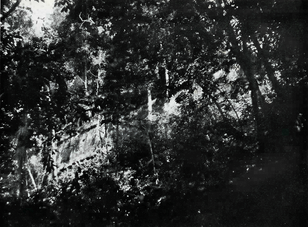
Results
The Museum Expedition accumulated a great deal of valuable information, much of it in fields other than archaeology, and brought back over 200 airplane photographs and about 50 taken on land. The most important geographical information relates to the formation of the peninsula of Yucatan and the country immediately south of it, and may be of considerable importance in tracing the past history of the Maya people. For what follows, some allowance may be made for the fact that none of the expedition were practiced in aerial observation in this sort of country or had more than an elementary knowledge of geology. It must also be remembered that we saw this area just at the end of the rainy season. According to our notes, however, the physical geography of Yucatan is as hereafter set forth.
All the northern and northeastern part of Yucatan is an absolutely level limestone plain covered with dense vegetation. In the northwestern part, however, starting a little north of Uxmal, in the state of Yucatan, a range of hills runs southwest toward the port of Campeche and another spur southeast nearly to the boundary line dividing the state of Yucatan and Quintana Roo. Beyond this point in a southeasterly direction the country is flat and low as far as the vicinity of Lake Bacalar. The entire central area of the peninsula drains to the southeast.
A band of broken rolling country runs straight south from Uxmal between the 89th and 90th meridians of longitude. At its northern end this region is very wide, running east from the 90th meridian to beyond Peto, but narrows to about fifty miles at the intersection of the boundaries of Yucatan, Quintana Roo and Campeche. It continues in this narrow belt due south for about forty miles from this intersecting boundary point and then begins to widen out toward the east as far as the 89th meridian. The country becomes flatter farther south, but rises again near the border of Guatemala, and at that point this strip of rolling country is a wide zone of low hills and long ridges sixty to seventy miles across. West of this area, beyond the 90th meridian of longitude and south of the 19th meridian of latitude, Campeche is nearly all low and wet with many swamps, pools, creeks and rivers showing through the jungle. East of this zone, from the 89th meridian to 88° 20′, southern Quintana Roo is also a low flat area, containing the beds of many dried-up lakes and rivers in the region lying between Lake Bacalar and 19 degrees 30 minutes north latitude. Several good sized lakes not shown on any map were also seen in this territory.
The mountains which rise in southwest British Honduras continue nearly north along its western boundary, becoming low hills and ridges as they run into Quintana Roo just inland from Lake Bacalar. Perhaps twenty miles due west and ten miles north of the southern end of this large body of water, a whaleback ridge eight hundred feet high and five miles long, running south-southeast and north-northwest, stands out as a landmark visible from many miles away. North of this high ridge lesser ridges and isolated hills are found on a low flat plateau country running to the north-northeast in a narrow zone, perhaps thirty to thirty-five miles wide and occasionally broken by stretches of swampy country, through Santa Cruz Bravo to the sea near Tuluum. East of this slight plateau, which may be an ancient shore line, Quintana Roo is low and soggy all the way to the sea; west of it is the region of dried-up water courses and scattered lakes already mentioned.
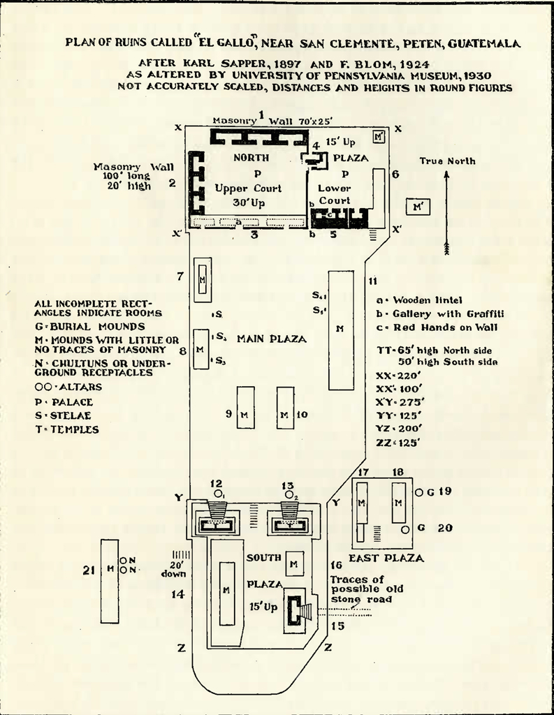
The formation of the Yucatan peninsula, as seen from above, strongly suggests that the entire area has risen considerably within comparatively recent times, possibly even within the past 1500 to 2000 years. All southwestern Campeche, and southeastern Quintana Roo east of the zone of low plateau country, already described, are today almost at sea level and are so swampy as to be practically uninhabitable. This in itself would not be of great significance, but perhaps becomes so when coupled with the existence of the great area of ancient dried-up water courses in the central territory between 88 degrees 20 minutes and 89 degrees west longitude and 18 degrees 50 minutes to 19 degrees 50 minutes north latitude. A slow elevation of the peninsula which would drain this central area southeastward toward the sea and raise the land all along the coast from below sea level seems a likely explanation of the ancient dried-up water courses inland and at the same time the negligible elevation of the country bordering the sea.22 Whether or not the peninsula has recently risen, however, the physical aspect of the region explored seems to have a direct bearing on the possible migration routes of the Mayas into Yucatan and to be a valuable guide to the location of new sites.
Almost all of the important First Empire cities found in British Honduras are in the low hills in the western part of the country and not in the flat plains near the sea. This higher land continues northward all along the western boundary of this colony and then becomes the narrow level plateau set with hills and broken by lower areas already described running past the whaleback ridge behind the Bacalar Lagoon through Santa Cruz as far as Tuluum and possibly Coba. It appears to offer by far the most satisfactory route for the migrations or settlements of the people who populated the east coast of Yucatan in times long passed away. Whether or not the eastern side of this low plateau was the shore of the sea in those far-off days and so perhaps was approached in canoes by the tribes migrating northward is a question on which only a geologist who could date the possible rising of the peninsula is competent to express an opinion.
It is of interest to note that Tzibanche and two other new sites found by the Carnegie Institution-Lindbergh flight of 1929 and one of the four new sites found by the University Museum Expedition are in this higher country immediately back of Bacalar. Moreover, if the thirty-five mile wide zone already mentioned be drawn with the western shore of Lake Bacalar as its eastern limit and this zone prolonged north-northeast to Tuluum it will take in new ruins, II, III, IV, V, VII and VIII located by the Carnegie Institution-Lindbergh flight and Ruin D (see map) as well as Muyil, Tuluum and possibly Coba. Thus the probable zone of the settlements and northward migrations of the east coast Maya tribes a thousand years and more ago, which can be deduced from the geography of the region, is apparently substantiated by the recent discoveries of many important ruins almost entirely within the favorable area indicated by the formation of the land.
Arguing from the same analogy, the Mayas of the First Empire who came north into the country around Uxmal presumably made their way over long periods of time through the band of rolling country in the area just west of the 89th meridian previously described, as the eastern area of the peninsula and its southwest coast region were so low and wet as to be impassable to large bodies of people. This theory of another favorable settlement and migration route in the west central area of the peninsula between 90 and 89 degrees west longitude is borne out by the Blom-Ricketson-Spinden maps. These show many ruined sites throughout this region of rolling ridges, running roughly from Tikal in north Guatemala to Uxmal in western Yucatan; and the two new ruins (B and C) found by the University Museum in northern Guatemala are just inside the boundaries of this zone. How far these geographical theories will finally fit the archaeological facts cannot be determined until much more work has been done in the southern territory of Quintana Roo, northwestern Guatemala, and southeastern Campeche.
A number of other lesser items of geographical knowledge were also obtained, which have been generally covered in the preceding pages of this article and may be summarized briefly as follows:
(a) The expedition’s maps showed a large lagoon at the northeastern end of the peninsula of Yucatan, covering many miles in area. This is now nearly grown over with vegetation except for one or two small water courses, and future maps and coast charts should be changed accordingly.
(b) In northeastern Yucatan a chain of three separate lakes was found running nearly northwest and southeast, with three smaller bodies of water around the largest one, which was over a mile long and about three-quarters of a mile wide. These lakes are incorrectly shown on the Blom-Ricketson Spinden maps, as two lakes, and are marked Coba. They are not the lakes of Coba, but an entirely different group located at approximately 20 degrees 38 minutes north latitude and 87 degrees 42 minutes west longitude, almost due west from the town of San Miguel on Cozumel Island, about twenty-eight miles inland from the village of Carmen, and nearly ten miles north of the lakes and ruined city of Coba.
(c) The lakes at Coba, on and near which are situated the well-known Maya ruins of the city of the same name, are four in number, and run in an almost straight chain west-northwest and east-southeast. The two largest are at the western end of the chain and are respectively about 2500 and 2100 feet long, separated by a narrow tree-covered neck of land. These lakes are at approximately 20 degrees, 30 minutes north latitude and 87 degrees 42 minutes west longitude. After allowing for wind drift, they seem to be directly west of a point about nine miles north of the extreme southern tip of Cozumel Island and approximately 25 miles inland from the sea.
(d) According to calculations made from the plane by dead reckoning, the Indian village of Yaxuna, shown on the maps carried by the expedition as nearly due south of Chichen Itza, is eight to ten miles west of its map position. The Coba-Yaxuna causeway is, of course, correspondingly lengthened to about seventy-three miles.
(ef)) In central Quintana Roo, the expedition discovered at least three new lakes more than one mile long in a region about twenty-five miles northwest of Santa Cruz Chico at the northern end of Lake Bacalar. None of these bodies of water is the lake known as Lake Payegua, found by the Carnegie Institution-Lindbergh flight of 1929 while searching for Lake Chichan-canab, and none are shown on any of the expedition’s maps.
(g) Most maps of Campeche show a tramway running almost east from a short distance up the river at whose mouth the town of Champoton is located. This, we were advised, was incorrect. According to Messrs. Moore and Shumaker of Carmen, Campeche, this tramway runs south-southeast, instead of almost east, to Juarez, a place about twenty-five miles north-northwest of the lake and village of Silbituk. This lake and village are about sixty miles east of the eastern end of the Laguna de Terminos instead of approximately fifty-two miles, as shown on maps carried by the expedition. This added distance from Silbituk to the sea is doubtless correct because the Laguna de Terminos is not much more than forty-five miles across in an east and west direction from a point just north of the mouth of the Mamantel and Candelaria rivers to the town of Carmen, instead of somewhat over fifty miles as shown on the expedition’s maps. As the island of Carmen is probably correctly located, the north and south shore line of the Laguna de Terminos should be extended at least five or six miles to the west. The north and south dimensions of this large lagoon were not accurately checked.
(h) The bay in the Laguna de Terminos into which the Candelaria and Mamantel rivers empty is almost due east from the port of Carmen.
(i) In the state of Chiapas along the upper reaches of the Usumacinta River, Lake Anaite and Lake Petha were found about where they were placed on the Blom-Ricketson-Spinden maps. About eight to ten miles northwest of Lake Petha, in a blank space on all maps of Chiapas carried by the expedition, another lake in the mountains was discovered as large, if not larger, than Lake Petha. This hitherto unknown lake, christened Laguna Margarita, is located at approximately 17 degrees 9 minutes north latitude and 91 degrees 46 minutes west longitude. Several other smaller lakes were found in the same region.
(j) Lake Bacalar and the bodies of water adjacent to it are not shown accurately as to size or shape on any maps carried by the expedition. Lake Bacalar is much longer, narrower and more crescent shaped and extends farther south than drawn on any charts, the lakes to the west and northwest are much larger, and the distance between Lake Bacalar and Chetumal Bay does not seem to be more than ten or twelve miles instead of nearly twenty miles as given on most maps. The photographic map of this area [Plate 33] shows clearly the proper location of the various bodies of water within it and their approximate size, as well as the width of the land between Lake Bacalar and Chetumal Bay. It should, however, be noted that these lakes were probably unusually full at the time of our trip at the end of the rainy season. A full size mosaic photograph of this area has been put together and should be of great value to future map makers of this little known area of Yucatan. It would, of course, be even more useful if the photographs were enlarged. A scale of this photographic chart can be made when desired.
Image Number: 19089, 19090
In addition to the above geographical data the expedition secured a great deal of information about the population of certain zones which may be of some importance.
(a) The great territory of Quintana Roo, with the exception of Payo Obispo and Bacalar, a few little villages along the sea, and the towns of Santa Cruz de Bravo and Saban, is practically uninhabited. It seems doubtful if the total population of this immense area, outside of Cozumel Island, exceeds 5000 people and the true number is probably considerably less.
(b) The east central part of the peninsula of Yucatan, in an area lying approximately between 19 degrees 20 minutes and 20 degrees north latitude and 88 degrees 20 minutes to 89 degrees 20 minutes west longitude, with the exception of the village of Saban, appears to be completely uninhabited. The expedition could see in its flight perhaps 3500 square miles of this country, and the most careful observation failed to show a single hut, clearing, field, or any other sign of human life. It was also covered twice by the Lindbergh-Carnegie Institution flights of 1929, whose report on this general area is substantially the same. This part of Yucatan includes the low area full of dried-up water courses which has already been frequently referred to.
(c) That portion of the state of Campeche lying south and west of 90 degrees west longitude and 19 degrees north latitude seems also uninhabited, with the exception of a small settlement at Lake Silbituk and a few scattered huts along the Mamantel and Candelaria rivers. The Museum Expedition covered the northern part of this region in its flight southwest to Carmen, and the southern part in its journey from Carmen to Belize. It is doubtful if this territory, covering 4000 square miles has in all 1000 inhabitants. A large part of it is so low and full of swamps as to be nearly uninhabitable, although here again we saw it at the end of the rainy season and much of it may be dry enough during a large part of the year to be suitable for cattle raising and agriculture.
(d) The Museum flight went over the valley of the Usumacinta River from its gorge, near Tenosique, southwest to Yaxchilan, thence to Lake Petha, and thence northwest to the vicinity of Palenque. On this flight an area of at least 3000 square miles was plainly visible, and, with the exception of three Indian huts on Lake Petha, no signs of human habitation were seen. The country itself is so wild, broken and jagged, with dense tropical jungles everywhere, that it appears to be almost uninhabitable except along the shores of rivers, streams or lakes.
(e)Northern Guatemala from the air seems completely uninhabited. No clearings, huts, nor any evidences of man were visible. In all probability this region is only occupied by the chicle gatherers for a few months in each year, and it is possible that it is without any permanent human habitations.
(f)Quintana Roo, southeast of a line from the northern end of Lake Bacalar through Santa Cruz Bravo to Tuluum on the sea is, for the most part an area of swamps and is probably uninhabitable except along the coast. The northeastern part of the same province, while not clearly swampy, is so low lying and wet that it is not now suitable for human habitation except on its shore line.
Besides the above geographical and ethnological data the following points as to the usefulness of an airplane in work of this kind seem worth stating as a matter of interest to those who are considering further exploration of the same general sort.
(A) A twin motor Sikorsky amphibian, well looked after and competently handled by a splendid organization such as the Pan-American Airways, is a safe and wonderfully efficient aid to the exploration of unknown country, particularly when covered with tropical vegetation.
(B) From the plane, geographical features such as hills, lakes and water courses can be seen, mapped and photographed in a way that is impossible by any other means.
(c) Such a plane can land on and take off from comparatively narrow rivers with currents up to ten miles an hour, and from lakes more than six feet deep and a mile or more in length, regardless of the height of surrounding vegetation.
(d) The size and power of the Sikorsky amphibian plane used by the Museum expedition added to its safety, but these same advantages made it dangerous to land on bodies of water surrounded by trees and less than a mile in length, such as the lakes at Coba. There are, however, several types of planes capable of landing on half a mile or less of water over five feet deep if carrying a fairly light load, regardless of surrounding vegetation. It is, however, extremely dangerous to attempt to fly long distances over the jungles of this region in a single engined plane, on account of the difficulty of getting out of the wilderness in the event of a forced landing.
(e) The Museum Expedition demonstrated the practicability of dropping materials by parachute to ground parties. The experiment made at the Yaxha Lakes showed that supplies can be landed by this means so gently that they will not be damaged.
(f) For purely archaeological exploration the fast flying heavy airplane is of little value in very broken hilly country covered with dense vegetation. The expedition flew within a hundred feet of the well-known site of Yaxchilan on the upper Usumacinta River and none of our party could see any traces of these ruins. In addition, we spent some minutes in trying to locate from the air the ruins of San Clemente, where we had spent two full days thinning out the vegetation, but were completely unsuccessful.
(g) It is exceedingly difficult to pick out from an airplane archaeological sites of Maya ruins covered with vegetation except in flat country or where the ruins are on or near the top of a ridge. In the latter two cases the sites can be located by flying so low that they stand out as elevations on the skyline. If the country is broken, this is, of course, impossible. Even in flat country all the available sites cannot be found, as it is not safe to fly low enough to see them except for very short stretches of time. Cenotes, which show up well from the air, are sometimes a valuable clue in Yucatan, as most cities in that area are near such natural wells.
(h)In this kind of observation, color is more important than shape. In other words, a white piece of masonry is much easier to pick out at a distance from the air than the whole jungle-covered mound of which it is only a part.
(i) It is the personal opinion of the writer that the vegetation on the ruins in the gray green jungle of northern Yucatan seems somewhat darker in color than that of the surrounding area; and that just the reverse applies to ruins in the rain forest area farther south; the vegetation on ruins in that region being apparently somewhat lighter in color than the adjacent zone.
(j) The responsible head of an expedition and the pilot of the plane should be connected by head-phones so as to permit speedy and accurate instructions as to change of direction on sighting a desired objective.
(k) Field or marine glasses are of little or no value in observation work from a fast flying plane, principally on account of the incessant motion.
The archaeological results of the trip, while not remarkable in the number of new sites discovered, seem important in some other respects. Under the portion of this report dealing with the geography of the area, reference has already been made as to the probable migration routes by which the Maya peoples came from the south into the peninsula of Yucatan along the rolling country in eastern Campeche and by way of the broken plateau running from just west of the Bacalar Lagoon to Tuluum. The importance of this geographical hypothesis lies in defining the area in which archaeological work should be undertaken. It is evident that the most likely portions of the Maya area for work in the next few years on the east coast is in the zone running up northwestern British Honduras through the country immediately behind the Bacalar Lagoon and thence in a line up to Tuluum or Coba,23 and especially the region around the whaleback ridge west of the Bacalar Lagoon. In the western half of the peninsula, the most promising field is probably in the higher rolling country running from the ancient city of Tikal to Uxmal, and particularly in the parts of this zone lying in southeastern Campeche and northern Guatemala between 89° 30′ and 90° west longitude.
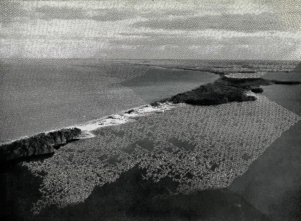
Image Number: 18952
On the other hand, vast stretches of land in southwestern Campeche, the area to the east of a line from the north end of the Bacalar Lagoon to Espiritu Santo Bay, the extreme northeastern part of Yucatan, and a zone covering the entire delta of the Usumacinta River from the hills of Palenque to the sea, are all so low and swampy that they are but sparsely inhabited today and in all likelihood could never have supported a large enough number of people to construct important cities in the past. Moreover, almost in the center of the peninsula of Yucatan is an extensive zone running from 19 degrees 20 minutes north latitude and 88 degrees 20 minutes west longitude, to 20 degrees north latitude and 89 degrees 20 minutes east longitude containing many lakes and many more dried-up water courses. This area appears in the not distant past to have been too swampy to have supported any great population, and, therefore, may also be tentatively eliminated from further archaeological research until the other much more promising areas have been thoroughly examined. Again, the country from the gorge of the Usumacinta River near Tenosique south to Yaxchilan and for many miles on both sides of the valley of that great river is so wild, broken and covered with almost impenetrable jungle that no ruins can probably be found from an airplane and it is doubtful on account of its precipitous character whether it could ever have supported a great number of people. The hills and slopes are so steep that if the vegetation were cleared off, the surface soil would probably be rapidly removed by the rains. The whole nature of this terrain makes it unlikely that large enough numbers of people to have constructed important cities could have found sufficient means of sustenence in such a country, with the possible exception of the valleys of a few rivers and their tributaries.
The above areas cover a vast stretch of territory, and it is safe to say that as a negative result the expedition has perhaps succeeded in excluding from further archaeological work, at least for many years to come, a region covering more than 40,000 square miles. Conversely, on the positive side, the selection, for reasons given, of the broad stretch of broken country in southeastern Campeche and northern Guatemala, and the narrow band of low plateau country in western British Honduras and eastern Quintana Roo as the most likely sites for additional work appear to narrow the desirable zones for future exploration to a comparatively small area, not exceeding perhaps 10,000 square miles in the western region, and 5000 square miles in the eastern part of the peninsula. These conclusions based on geographical observations seem to be the most important results which have been accomplished from an archaeological point of view and by themselves might have justified the expedition. In addition, however, the following points are of considerable archaeological value:
(a) The expedition definitely located the position of Coba, the oldest Maya city in northern Yucatan. This site and the lakes upon which it is situated, were photographed from the air for the first time.
(b) The expedition traced and photographed for some distance a number of ancient causeways built perhaps 1500 years ago, and running in several directions from this city of Coba. Unfortunately their termini could not be located.
(c) A group of mounds near Valladolid in Quintana Roo, so symmetrically placed they are possibly the site of a new ruined city, was discovered and photographed from the air. [Ruin A.]
(d)Excellent aerial photographs were taken of several temples on the east coast of Yucatan and of the large sites of Tuluum, Chichen Itza, Uxmal, Kabah and Labna, these being probably the best known cities of the Maya Empire in Yucatan.
(e) In northern Guatemala the expedition found and photographed two new sites of ruined cities, one of them very large and with an immensely tall temple. [Ruins B and C.] These important ruins have never before been located, described, or photographed by white men.
(f) A recently discovered important site in Quintana Roo called Tzi-banche was reached by a route different from that covered by the Carnegie Institution-Lindbergh flight or by Dr. Thomas Gann, who discovered it by land. A few miles from Tzibanche the expedition located a new set of ruins with at least three temples and a ” cenote,” not hitherto reported or shown on any map. [Ruin D.]
(g) While several new lakes were seen and closely examined, no ruins were found near their shores, a further substantiation of the well-known fact that the Maya in general were averse to building near such bodies of water.
(h) The expedition went by airplane from Belize to Lake Yaxha in northern Guatemala, and thence on foot to ruins about twelve miles inland called by some San Clemente and by others El Gallo. From information then available it was believed that these ruins had only been partially examined by archaeologists. A careful study was made of this site, several new features were found, accurate measurements were taken of its dimensions and the height of its buildings, and a number of excellent photographs of its various structures were obtained. It now appears that this site has already been described, although perhaps not in the same detail as that contained in this article or in that which may be given by Dr. Mason in a later monograph. No photographs have previously been taken at this site and these, with the measurements made of the buildings and plazas, and the discovery of a good deal of new material made the land trip well worth while from a scientific point of view.
Some Suggestions and Conclusions
The members of the expedition are unanimous in their belief that with the coming of the autogiro plane, a vast field of usefulness is now opened for this means of transportation as an aid to archaeological work. The airplane can cover in one hour a stretch of country which takes a week to traverse by mule or on foot and the perfected autogiro can hover over, land on, and take off from an exceedingly small area of water or of cleared and leveled hard ground.
The scientific bodies doing archaeological work in the Maya region in the future, when these planes have been commercially perfected and made available, can function much more efficiently if they will join in the purchase of a common plane of this type and in engaging the services of a pilot, the plane to be kept at Belize in British Honduras. This is the center of a wheel whose spokes run all over the Maya area, to Copan in Honduras, Piedras Negras on the Usumacinta River, the Peten country in northern Guatemala, and the Bacalar region in Quintana Roo, all of them districts of leading archaeological importance.
If the site to be explored is not on an available body of water, the ground expedition should immediately clear a space of only three or four acres at its permanent camp, level it off and give it a firm foundation. The expedition could then transport by autogiro a gasoline motor with which, if necessary, a well to supply water could be driven, and electricity generated with which to operate a sending radio. Once this was accomplished, all further communication with the expedition could be by radio, by which all future supplies needed could be ordered when desired and brought from Belize by the plane. By this method an enormous saving in time and money could be effected in transporting men and provisions, and the resultant quick communication with the outside world and freedom from worry about the results of illness or accident — a serious matter to men a week or more away from medical aid — would undoubtedly increase the efficiency and add materially to the happiness of the personnel of the expedition. At the proper time the writer will be glad to cooperate in working up a committee to consider and plan out this phase of the work.
While the Museum’s Expedition was successful in locating several unknown sites from the air, and with further practice in observation of this kind could probably have picked out several more, it is doubtful if such discoveries by themselves are worth the cost of making them.
Invaluable as the airplane is for general exploration and transportation, it is the writer’s opinion that new ruins located by air in a district covered with dense vegetation such as the Maya country are of little scientific value until some means can be devised by which they can be found again by parties on the ground. In the dense forests of Yucatan and Guatemala, the Carnegie Institution-Lindbergh flight of 1929, and the recent expedition of the University Museum located from the air in all about a dozen sites, which were not known before. Granting the abstract scientific interest of these discoveries, it is hard to see how, standing alone, they have any tangible value. The map position of each of these sites can, of course, be plotted, in terms of degrees and minutes of latitude and longitude; but in the course of its flight the wind drift and other factors affect the speed of a plane so that the unavoidable error in the exact location of any site by compass course and dead reckoning cannot be less than a mile or two in both latitude and longitude, and is probably considerably more. Unless the trails of chicle gatherers run near these ruins they will have to be found again by cutting through miles of jungle to reach them; and when these trails do run near such sites, the chicle gatherers will find and report them in a very short time.
The vegetation in the great rain forest in this part of’ the world is so dense that a ground party in virgin jungle could cut its way past a structure the size of a modern football stadium and fail to see it at a distance of two or three hundred yards. Consequently, the unavoidable error of a mile or more, north or south, and an equal error east and west in plotting the ground position of ruins located only from the air may make it almost impossible to find them again by land unless a very large and expensive party is sent in to cut numerous trails in every direction until the site is discovered.
It may be feasible after relocating these new sites from the air, which would not be difficult, to drop a series of bombs or other containers full of mustard or other destructive gas over a large area of the jungle in lines in the form of a square or triangle with the site in the middle, so that the land party by picking up the trail of destroyed vegetation would be given an indication of the position of the ruined city. The destructive gas would have to be so handled that it acted on the underbrush and not on the tops of the immense trees, as the destruction of the upper foliage, especially in the southern area, would probably not be visible from the ground far below.
Another and possibly better method would be to lower from an autogiro or drop by a parachute on one of the ruins, a strongly constructed machine which would send out electrical waves for a considerable period to be picked up with appropriate instruments by the land party. Electrical devices exist by which the exact source of a distant current of electricity can be accurately located and if suitable apparatus of this sort were carried, the electrical machine at the site of the ruins would guide the land party to it. Of course, a complete aerial survey of the entire area resulting in overlapping mosaic photographs would be of immense value in determining the exact location of these sites, as a number of definitely known points could then be used as bases for compass bearings and the position of such new ruins much more accurately plotted than is now possible. This, however, is a very costly undertaking and cannot be expected for some time to come.
These are all interesting speculations which may or may not be practicable. Nevertheless until some sure method can be worked out to guide a land party through virgin jungle to the site of ruins located only from above, finding more new sites of ruined cities by airplane in the vast tropical forests of the Maya country appears to be of very little real scientific value and perhaps can more properly be classified as a fascinating although somewhat expensive sport.
Appendix A
List of Equipment for Four Persons Taken on University Museum Aerial Expedition to Central America
Cooking outfit
Pocket compass (4)
Flashlight (4)
Spare batteries
Bulbs
Machetes (4)
Binoculars (3)
Blom-Ricketson-Spinden maps
Succinchloromide tablets
Pocket knives (4)
Blankets (4)
Cross section maps and map case
Map board
Musettes (4)
Pencils
Fountain pen
Pocket thermometer
Bottle whiskey
Matches
String
Clinical thermometer
Watches
Fish flies
Snake bite serum (4)
Shot gun (16)
Buckshot (25)
No. 2 (25)
No. 5 (25)
Climbing irons
Game getter and ammunition
Chocolate (4)
Food
Medicine
Snake pencils
Rope (100 feet)
Large mosquitero (1)
Small mosquiteros (4)
Map paper
Brush
Orange sticks
Copy paper
Carbon
Ink
Matches (4)
Canned alcohol
Hammocks (4)
Altimeter
Canteens (4)
Water bag, one gallon
Fishline and hooks
Hunting knife
Cigarettes
Aerial camera (1)
Graflex camera (1)
Moving picture camera (1)
Rolls aerial film (5)
Rolls graflex film (60)
Moving picture film (1000 feet)
Extra clothing
Toilet articles
Appendix B
Pilot’s Notes on Flight
December 3, 1930: San Julien, Cuba, to Cozumel via New Lakes
| Bearing, degrees | Departure | Arrival | Traveling Time | Nautical Miles | Speed, knots | Observations | |
|---|---|---|---|---|---|---|---|
| San Julien | 256 | 9:35 A | …. | … | … | … | Zigzagging territory. |
| Cape Catoche | … | 11:08 A | 11:08 A | 1:33 | 165 | 104 | |
| Solferino | 188 | 11:31 A | 11:31 A | :23 | 29 | 75 | |
| Lakes | 79 | 11:57 A | 11:57 A | :26 | 42 | 97 | |
| Coast | 100 | 12:21 P | 12:21 P | :24 | 34 | 85 | |
| Cozumel | … | …. | 12:30 P | :09 | 13 | 85 |
Course plotted from Lake Coba to Cozumel
| Bearing, degrees | Departure | Arrival | Traveling Time | Nautical Miles | Speed, knots | Observations | |
|---|---|---|---|---|---|---|---|
| Lake Coba | 95 | 4:06 P | …. | .. | .. | .. | |
| 2 miles north of South Point light, west coast, Cozumel Island | .. | 4:35 P | 4:35 P | :29 | 42 | 85 | |
| Cozumel | .. | …. | 4:48 P | :13 | 18 | 85 |
December 4, 1930: Cozumel to Coba and return.
We took off at 10.54 A. se., following a bearing of 280 degrees to the coast. Because of the territory we were flying over and that the mission of the flight required occasional low flying, we flew on one engine from Cozumel over, to determine what altitude could be maintained with a 3,200-pound load. We held 250 feet without difficulty. We flew down the coast, circling ruins and zigzagging inland in search of indications of other ruins. At Blossom Point we headed west and examined Muyil and the lakes and territory adjacent to it. No additional mounds or ruins were observed. We then examined the territory between Muyil and Coba. At Coba we flew east and then west over the Lakes. The wind was ten miles per hour from the east and as near as we could calculate with a small wrist watch our travel over the largest lake averaged 17 seconds. We estimated our speed at 85 knots and judged the lake to be about 2,500 feet long.
| Bearing, degrees | Departure | Arrival | Traveling Time | Nautical Miles | Speed, knots | |
|---|---|---|---|---|---|---|
| Coba | 90 | 1:16 P | …. | .. | .. | .. |
| Coast | .. | …. | 1:36 P | :20 | 25 | 75 |
| Cozumel, 9 miles north of South Point | .. | …. | 1:46 P | :10 | 16 | 85 |
| PAA Base | 35 | …. | 1:54 P | .. | .. | .. |
December 4, 1930: Cozumel to Merida.
| Cozumel | Bearing, degrees | Departure | Arrival | Traveling Time | Nautical Miles | Speed, knots | Observations |
|---|---|---|---|---|---|---|---|
| Cozumel | 260 | 3:15 P | …. | :34 | 50 | 90 | |
| Coba | 270 | 3:51 P | 3:49 P | :12 | 18 | 90 | Note: Observed causeways. |
| 330 | 4:03 P | 4:03 P | :08 | 13 | 90 | Mound to N.W. near farm: no masonry apparent. | |
| 235 | 4:13 P | 4:11 P | :10 | 15 | 90 | ||
| Yaxuna | 250 | 4:28 P | 4:23 P | :17 | 26 | 90 | Taking pictures. |
| Chichen Itza | 35 | 4:45 P | 4:40 P | :06 | 10 | 90 | Taking pictures. |
| Merida | 280 | …. | 5:38 P | :43 | 64 | 90 | Turned to right of course to observe Motul |
| 2:13 | 196 |
Faint shadow line bearing east and west on foliage observed on leaving Coba.
Scale of nautical miles taken from latitude 20 equals 196 nautical miles (224 land miles).
December 5, 1930: Merida to Carmen.
| Bearing, degrees | Arrival, Departure | Traveling Time | Nautical Miles | Speed, knots | Observations | |
|---|---|---|---|---|---|---|
| Merida | 193 | 1:56 P | :22 | 33 | 90 | |
| Uxmal | 132 | 2:18P | … | .. | … | |
| … | 2:19 P | :06 | 8 | 80 | :01 Hilly country. | |
| Kabah | 132 | 2:28 P | :09.7 | 13 | 80 | :03 Many ruins along course. Speed decrease due to frequent changes in course and light north wind. |
| Labna | 91 | 2:38 P | :03 | 4 | 80 | |
| 132 | 2:41 P | :03 | 4 | 80 | ||
| 91 | 2:44 P | …. | .. | 80 | :01 Course changes indicate zigzagging, for observations and photography. | |
| … | 2:45 P | :02.2 | 3 | 80 | ||
| … | 2:47 P | …. | .. | 80 | :01 | |
| 132 | 2:48 P | :06 | 8 | 80 | ||
| 185 | 2:54 P | :02.2 | 3 | 80 | ||
| 123 | 2:56 P | :17 | 22 | 80 | Lake Chichanacanab not apparent. Cloud shadows affecting ground observation. | |
| 123 | 3:13 P | :09 | 12 | 80 | ||
| 140 | 3:22 P | :03 | 4 | 80 | Large swamp area like dried up lake. | |
| 135 | 3:25 P | :06.7 | 9 | 80 | Lake observed ahead. | |
| 110 | 3:31.7 P | :08.2 | 11 | 80 | ||
| … | 3:39.7 P | :08.2 | 11 | 80 | ||
| Unknown Lake | 186 | 3:41 P | :08.2 | 11 | 80 | Over lake. |
| 231 | 3:49.2 P | :28 | 37 | 80 | Climbing 5000. | |
| 250 | 4:17.2 P | :35 | 50 | 85 | ||
| Lake Silbituk | 266 | 4:52.2 P | :06 | 9 | 90 | Lake not seen. Crossed marshy area. Nosing over slightly. |
| 266 | 4:58 P | :15 | 25 | 100 | Sighted lakes on course ahead. | |
| … | 5:08 P | …. | .. | 103 | Sighted lagoon and gulf. | |
| 266 | 5:13 P | :13.5 | 23 | 103 | Passing lakes. | |
| 266 | 5:27 P | :13 | 22 | 103 | Over lagoon. | |
| 245 | 5:40 P | :14 | 25 | 103 | ||
| Carmen | … | 5:54 P | …. | .. | … | |
| Landed | … | 5:56 P | …. | .. | … |
Total distance, 336 nautical miles (386 land miles); time, 3 hours 58 minutes; average speed, 85 nautical miles per hour.
Distances taken from longitude 86°, latitude 18° to 19°.
December 6, 1930: Carmen to Upper Usumacinta River and return
| Bearing, degrees | Arrival, Departure | Traveling Time | Nautical Miles | Speed, knots | Observations | |
|---|---|---|---|---|---|---|
| Carmen | 149 | 9:02 A | :39 | 56 | 90 | |
| 277 | 9:41 A | … | .. | .. | ||
| 138 | …. | :04 | .. | .. | Observing river. | |
| Santa Ana | 169 | 9:45 A | … | .. | .. | Landed. |
| … | 11:53 A | :07 | 9 | 80 | ||
| 190 | …. | :06 | 8 | 80 | ||
| Tenosique | … | 12:06 P | … | .. | .. | Landed. |
| 169 | 1:55 P | :10 | 13 | 80 | ||
| General Bearing | 125 | 2:05 P | :15 | 18 | .. | Following river. |
| General Bearing | 125 | 2:10 P | :15 | 20 | 80 | Following river. |
| 288 | 2;25 P | :05 | 8 | .. | Changed course by request. | |
| 114 | 2:30 P | :12 | 16 | 80 | Following river to Yaxchilan. | |
| Yaxchilan | 279 | 2:42 P | :32 | 41 | 78 | Bends in river recognized as Yaxchilan by party. |
| 323 | 3:14 P | … | .. | .. | ||
| Lake Petha | 350 | 3:16 P | :04 | .. | .. | :02 Zigzagging. |
| … | 3:19 P | … | .. | .. | ||
| New Lake, Laguna Margarita | 323 | 3:22 P | … | 28 | 85 | :03 Second group of lakes. |
| Near Palenque | 360 | 4:05 P | … | 8 | .. | Looking for ruins in vicinity. |
| General | 90 | …. | … | .. | .. | Palenque. |
| S.W. Monte Cristo | 240 | …. | … | .. | .. | Returning to Carmen. |
| West of Palenque | 360 | 4:10 P | :25 | 37 | 90 | |
| 10 | 4:35 P | :15 | 23 | 92 | ||
| Carmen | … | 4:50 P | … | .. | .. |
December 7, 1930: Carmen to Belize.
| Bearing, degrees | Departure | Arrival | Traveling Time | Nautical Miles | Speed, knots | |
|---|---|---|---|---|---|---|
| Carmen | 120 | 10:50 A | 11:18 A | :28 | 43 | 90 |
| 130 | 11:18 A | 11:19 A | :02 | 2 | 90 | |
| 126 | 11:19 A | 11:26 A | :07 | 12 | 95 | |
| 107 | 11:26 A | 11:31 A | :05 | 8 | 95 | |
| 94 | 11:31 A | 11:58 A | :27 | 42 | 90 | |
| 122 | 11:58 A | 12:09 P | :11 | 18 | 95 | |
| 138 | 12:09 P | 12:13 P | :04 | 6 | 90 | |
| 90 | 12:16 P | 12:18 P | :02 | 3 | 90 | |
| 160 | 12:18 P | 12:21 P | :03 | 4 | 90 | |
| 70 | 12:24 P | 12:53 P | :29 | 43 | 90 | |
| 94 | 12:53 P | 1:18 P | :26 | 39 | 90 | |
| Belize | 100 | 1:18 P | 1:26 P | :08 | 12 | 90 |
December 7, 1930: Carmen to Belize.
- 10:50 A. M. Leave Carmen.
- 11:21 A. M. Marsh to left small river with rapid stream west.
- 11:22 A. M. Lake one mile.
- 11:30 A. M. Land wooded few hills and large swamp, hills about 500 feet above sea level.
- River running north dried southeast.
- 11:31 A. M. Huts on river running E. x N.E.
- 11:32 A. M. Lake 2 miles long running E. & W. 4 miles to south of course.
- 11:35 A. M. Small lake leaving swampy area.
- 11:36 A. M. Passing river that runs north and south that turns east 1 mile south of us.
- 11:41 A. M. Sighted pyramids.
- 11:44 A. M. Over small river that runs E. & W. and terminates in small marsh area.
- 11:47 A. M. Over lake one mile long runs N. & S., 2 islands in it.
- 11:56 A. M. Sighted mound.
- 12:02 P. M. Small river.
- 12:05 P. M. Small river.
- 12:11 P. M. 4 pyramids.
- 12:33 P. M. Over mountain area since last observation, has shown no cleared places, lakes
- or rivers.
- 12:40 P. M. Leaving low mountainous area.
- 12:43 P. M. Small river. N. & S.
- 1:00 P. M. Over large swamps.
- 1:04 P. M. Small lake Yi mile long—round lake also.
- 1:06 P. M. Over river.
- 1:26 P. M. Arrive Belize.
December 9, 1930: Belize to Yaxha.
- 7:11 A. M. Left Belize on compass course of 245 degrees with a N.-N.E. wind of about
- 8 M.P.H. increasing slightly inland.
- 7:16 A. M. Passed northern lagoon on our left.
- 7:22 A. M. Over low scattered mountain range that runs generally N. E. to S. W.
- 7:25 A. M. Circling to observe weather.
- 7:28 A. M. Over river fork running S. W.
- 7:30 A. M. Over flat wooded land.
- 7:32 A. M. Over mountains.
- 7:43 A. M. Over stream.
- 7:53 A. M. Over river rapids. Sky 8/10 overcast, two cloud strata, one above us at 3,500
- and one below at 2,800 feet; visibility hazy; altitude 3,200.
- Town three miles to right. 10/10 overcast 3,400 feet, stormy ahead and 6/10
- overcast at 3,000 feet clearer to N. W. and north. Over river flowing south-
- west.
- 7:59 A. M. Sighted lakes 5 miles to right. Bearing 312 degrees.
- 8:04 A. M. Over lake.
- 8:05 A. M. Circled lake and landed. Rate of speed to sighting lake 101 knots. Distance
- 82 land miles.
- Return flight to Belize made to 9,000 feet without incidental observation.
- On a later trip the mountains were observed not to exceed 1,500 feet on
- course from Belize to Yaxha. The mountains well to south extend up
- above 3,000. Altitude of lake 600 feet.
December 13, 1930: Belize to Cozumel.
- 7:05 A. M. Left Belize for Cozumel via ruins on N.-N.W. course. Tzibanche reported
- west of lagoon Bacalar. With a light northwest-north wind.
- 7:15 A. M. Left Bayshore. A number of lakes inland about 20 miles bearing west from
- us. The country along the shore is low and marshy with many bayous
- and is thickly wooded inland.
- 7:20 A. M. Observed many small wet areas inland.
- 7:23 A. M. River and town.
- 7:27 A. M. Wet, heavily wooded flat land.
- 7:31 A. M. Lake 4 miles west of course with 2 islands in it. Suitable for landings. There are a group of lakes in this vicinity.
- 7:33 A. M. There is a large bayou extending inland about 4 miles, generally bearing southwest from Rocky Point in Chetumal Bay, U. S. Navy Chart V250 and covering the area where Sarteneja is marked on the Blom-Ricketson chart.
- 7:38 A. M. Passing village on lake with 8 islands on it. Good landing.
- 7:44 A. M. Passing farm with 2 large barns.
- 7:45 A. M. Passing well cultivated land. About 5 miles south of southern end of Bacalar tip.
- 7:50 A. M. Village on river, running E. and W. Lake with island 4 miles to right. Enter-
- ing hilly country.
- 7:55 A. M. Turned to bearing 270 degrees and a point 3 miles S. of Whaleback Ridge, which is aptly described and easily recognized. It stands well above the surrounding hills at an altitude of 800 ft. Lagoon Bacalar was observed to be farther east from our course than the Blom-Ricketson charts would indicate.
- 7:58 A. M. Over trail running N. and S.
- 8:01 A. M. Circling large mound, which looks as though it might be of artificial construc¬tion. No ruins visible, so continued on course of 270 degrees.
- 8:02 A. M. At 8:02 we headed due south from a point about 3 miles due south from the southern edge of Whaleback Ridge.
- 8:05 A. M. At 8:05 we circled 4 mound formations. They were thickly covered with trees but looked as though they might be of artificial construction. No masonry was evident. There was some question as to the exact locality of the ruins with reference to Whaleback Ridge. Reported south of southern edge of ridge. So we took a bearing due north and slightly to the right of a parallel from the southern tip of the ridge. This country is quite hilly and distinction between natural and artificial construction hard to make. As we neared the ridge Mr. Madeira indicated 4 mound formations to our left about 3 miles bearing southwest from the southern tip of the ridge. We flew over and circled them closely without noticing any artificial construction. They also were very thickly wooded. We then examined the eastern and western side of the ridge without noticing any ruins.
- 8:15 A. M. At 8:15 we left the ridge bearing N.E. and noticed a group of 3 mounds about 3 miles bearing N.E. from the N.E. tip of the ridge. The ridge itself lies generally from N.E. to S.W. We continued on a bearing generally N.E. with occasional variations to observe mounds along the coast.
- 8:25 A. M. At 8:25 we were passing the western tip of a large crescent-shaped lake. The country was much flatter.
- 8:26 A. M. We turned to the right and reached the lake at 8:26.
- 8:30 A. M. We followed the lake and at 8:30 observed a very suspicious looking portion of the western shore where either masonry or the bank rose vertically from the water high enough to make it conspicuous. We circled twice for obser¬vation and photography.
- 8:37 A. M. At 8:37 the northern tip of Chetumal Bay was observed to be on our star¬board beam. From there to Espiritu Santo Bay the land is very flat and thickly wooded and appears wet. There are a few water holes and small swamp areas. To our west a fog bank of about 200 ft. altitude had gradually reached about an 8/10 overcast condition. We followed the shore of Espiritu Bay to Bird Point and from there to Cozumel. Over water the wind was slightly increased from the north.
(p>sup#number${$}+small+a[href=”#ref$”]{↪})
1 Mr. Mason has written a popular book on this expedition, which will shortly appear. ↪
2 Mr. Smith published a very good short account of the expedition in The Sportsman Pilot, in February, 1931. ↪
3 There are several different correlations of the Maya and Christian dates, varying by a total of nearly 520 years in the chronology of the First Empire. The correlation used in this article is the intermediate one proposed by H. J. Spinden and S. G. Morley. The subject is highly technical. The two theories of the leading American scholars are well set forth in Spinden’s The Reduction of Mayan Dates, Papers of Peabody Museum, Vol. VI, No. 4, Morley’s Correlation of Mayan and Christian Chronology, Papers of the School of American Archaeology, No. 11, and Spinden’s Maya Dates and What they Reveal, Brooklyn Institute Science Bulletin, Vol. IV, No. 1, 1930. The leading authorities today favoring a correlation later by about 260 years, are J. Eric Thompson in A Correlation of the Mayan and European Calendars, Field Museum Publication 241, and John E. Teeple of Carnegie Institution in Maya Astronomy, Contributions to American Archaeology No. 2, published by the Carnegie Institution. ↪
4 A Study of Maya Art, by H. J. Spinden, Peabody Museum Memoirs, Vol. VI, illustrated. ↪
5 Maya Architecture, by George 0. Totten, The Maya Press, Washington, D. C., illustrated. ↪
6 For a general outline of prehistoric Central American civilization see Ancient Civili¬zations of Mexico and Central America, H. J. Spinden, American Museum of Natural History Handbook No. 3, Third Edition, 1928. For a more detailed account of the Maya, see Gann and Thompson’s History of the Maya, Scribners, 1931. ↪
7 Geographical Review, April, 1930, pages 177-206, illustrated. ↪
8 The Maya Chronicles, pp. 226-227, by Dr. D. G. Brinton, privately published in Philadelphia in 1882. ↪
9 The Ancient Maya Causeway in Yucatan, by R. R. Bennett, Museum of the American Indian, Heye Foundation, 1930, illustrated.
Coba by Land and Air, by R. R. Bennett, Art and Archaeology, Vol. XXXI, No. 4, April, 1931, with illustrations. ↪
10 Geographical Review, April, 1930, page 203. ↪
11 Silver Cities of Yucatan, pages 265, 266 (Putnams). ↪
12 See Tuluum, an Archaeological Study of the East Coast of Yucatan, by S. K. Lothrop. ↪
13 For an interesting popular account of the work of Carnegie Institution at Chichen Itza, see Digging in Yucatan, by Ann Axtell Morris, Doubleday Doran, 1931, with many illustrations. ↪
14 Dr. Martinez has recently compiled a complete Maya-Spanish dictionary, published in Merida in 1930. ↪
15 Uxmal: The Great Capital of the Xiu Dynasty of the Maya, by Frans Blom, Art and Archaeology, December, 1930, Vol. XXX, No. 6, illustrated. See also Science News Letter, May 9. 1931. on. 298 to 300. illustrated. ↪
16 Geographical Review, April, 1930, pp. 190-1. ↪
17 An excellent description of these two extraordinarily interesting sites is found in Maya Cities by Dr. Thomas Gann, published by Duckworth, of London, England, in 1927. ↪
18 Maya Cities, by Thomas Gann, pages 64-92 (Duckworth, London, 1927), ↪
19 Geographical Review, April, 1930, page 198. ↪
20 Geographical Review, April, 1930, page 198. ↪
21 The position of this ridge and ruins is incorrectly shown on the accompanying map—Plate 1. The Bacalar Lagoon and other lakes extend farther south and lie more to the eastward than there shown; and the Blom-Ricketson-Spinden maps are also equally incorrect as to the same details of this area. ↪
22 In Civilization and Climate, Ellsworth Huntingdon argues strongly that the principal cause of the decline of the First Empire of the Mayas in the south was due to a climatic change. This would at least be accelerated by a rising of the area, which would also at the same time disturb its water courses and water supplies. ↪
23 The discoveries made by the Lindbergh-Carnegie flight as shown on the map are sufficient evidence of the importance of this area. ↪